IMAGES TAKEN NEAR TO
Grange Road, LONDON, SE19 3BY
Introduction
This page details the photographs taken nearby to Grange Road, SE19 3BY by members of the Geograph project.
The Geograph project started in 2005 with the aim of publishing, organising and preserving representative images for every square kilometre of Great Britain, Ireland and the Isle of Man.

There are currently over 7.5m images from over14,400 individuals and you can help contribute to the project by visiting https://www.geograph.org.uk
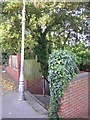
Image Map
Images are licensed for reuse under creativecommons.org/licenses/by-sa/2.0
Notes
- Clicking on the map will re-center to the selected point.
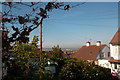
- The higher the marker number, the further away the image location is from the centre of the postcode.
Image Listing (186 Images Found)
Images are licensed for reuse under creativecommons.org/licenses/by-sa/2.0
Image
Details
Distance
1
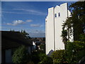
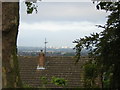
View from Beauchamp Road
There are fine views from the Upper Norwood Ridge around Beulah Hill and Grange Road. This is the view across South London from Beauchamp Road near the junction with Grange Road. The house on the right must have stupendous views.
Image: © Marathon
Taken: 21 Oct 2011
0.01 miles
2
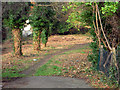
Walk through wooded area - between Grange Road and Beaulieu Heights
A pleasant wooded area, offering a walk between Grange Road up towards Beaulah Hill / Spa Hill. Sometimes referred to as The Lawns
Image: © Chris L L
Taken: 28 Dec 2008
0.02 miles
3
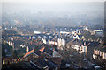
view from Grange Road over parts of SE London
Haze / air pollution is quite apparent even at 9/ 10 o'clock on a bright and breezy day
Image: © Chris L L
Taken: 29 Dec 2008
0.02 miles
4
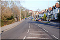
Looking up Grange Rd towards Beulah Hill
Photographed from traffic island at junction of Grange Road and Grange Hill
Image: © Chris L L
Taken: 29 Dec 2008
0.03 miles
5
Grange Road: view southwest to Sutton
Image: © Christopher Hilton
Taken: 20 Sep 2011
0.03 miles
6
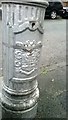
Croydon Borough arms on decommissioned lamp-post, Kingslyn Crescent, SE19
During 2013 the London Borough of Croydon decommissioned many of these old lamp-posts bearing the borough arms and replaced them with newer, brighter and more energy-efficient models. This, like many, was cut off at about four feet up and sealed up with insulating tape; the photo was taken whilst it was an amputated stump in this manner.
To see this in context go to Image
Image: © Christopher Hilton
Taken: 21 Oct 2013
0.04 miles
7
Kingslyn Crescent, SE19
The decommissioned lamp-post in the foreground can be seen in detail at Image
Image: © Christopher Hilton
Taken: 21 Oct 2013
0.04 miles
8
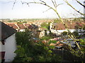
Grange Road: view westwards over the streets below
Image: © Christopher Hilton
Taken: 13 Sep 2011
0.05 miles
9
Grange Road: path down to Beauchamp Road
All along Grange Road, paths descend on the western side to the streets at a lower level.
Image: © Christopher Hilton
Taken: 13 Sep 2011
0.05 miles
10
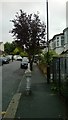
View west from the Norwood Heights
Taken from the short path that links Spa Close to Kingslyn Crescent (the houses lie on the latter): one of many paths on this side of the hill that link roads to others at a lower level.
Image: © Christopher Hilton
Taken: 7 May 2013
0.06 miles