IMAGES TAKEN NEAR TO
Grange Road, LONDON, SE19 3BW
Introduction
This page details the photographs taken nearby to Grange Road, SE19 3BW by members of the Geograph project.
The Geograph project started in 2005 with the aim of publishing, organising and preserving representative images for every square kilometre of Great Britain, Ireland and the Isle of Man.

There are currently over 7.5m images from over14,400 individuals and you can help contribute to the project by visiting https://www.geograph.org.uk
Image Map
Images are licensed for reuse under creativecommons.org/licenses/by-sa/2.0
Notes
- Clicking on the map will re-center to the selected point.
- The higher the marker number, the further away the image location is from the centre of the postcode.
Image Listing (200 Images Found)
Images are licensed for reuse under creativecommons.org/licenses/by-sa/2.0
Image
Details
Distance
1
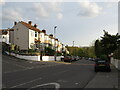
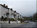
Grange Road, Upper Norwood
Grange Road is a residential road on a hillside in Upper Norwood, in the suburbs of south London.
Image: © Malc McDonald
Taken: 18 Apr 2022
0.02 miles
2
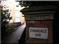
Victorian survival, Grange Road
The ghosts of a Victorian villa remain in the form of its gateposts, long after a block of flats took its place. The first half of the name can be seen at Image
I'm particularly fond of that firm, no-nonsense full stop.
Image: © Christopher Hilton
Taken: 20 Sep 2011
0.03 miles
3
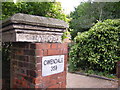
Victorian survival, Grange Road
The ghosts of a Victorian villa remain in the form of its gateposts, long after a block of flats took its place. Almost illegible is the word "Grange": the second half of the name can be seen at
Image
Image: © Christopher Hilton
Taken: 20 Sep 2011
0.03 miles
4
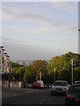
Grange Road, Upper Norwood: view south
In the distance, the towers of Croydon town centre and beyond them the green space of Roundshaw Park.
Image: © Christopher Hilton
Taken: 13 Sep 2011
0.04 miles
5
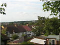
Grange Road
Down hill from Beulah Hill with Grangewood Park in the distance.
Image: © Robin Drayton
Taken: 24 Mar 2008
0.04 miles
6
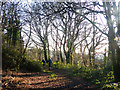
A path through The Lawns, Upper Norwood
The Lawns is predominately an open space but it is bounded on its north-eastern edge by a strip of attractive woodland.
The following shared description is provided by N Chadwick.
Image: © Robin Drayton
Taken: 20 Jan 2019
0.05 miles
7
Looking along the curve of the Norwood Heights: north-west from Grange Road
Image: © Christopher Hilton
Taken: 16 Sep 2011
0.06 miles
8
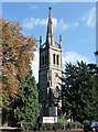
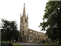
All Saints, Beulah Hill
The white brick tower of the church designed by James Savage in 1827-29. The lancets, recessed spire and flying buttresses are characteristic of Commissioners' churches, of which this is an example. Grade II listed.
The Church Building Commission was established in 1824 to oversee the building of more Anglican churches in urban areas which had experienced large increases in population due to the Industrial Revolution.
Image: © Stephen Richards
Taken: Unknown
0.07 miles
9
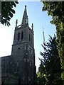
All Saints, Crystal Palace
Architect: James Savage. Built: 1829. According to "The Phoenix Suburb" by Alan Warwick, the church's graveyard was the cause of a Victorian scandal in that 3,025 corpses had been buried there when it was only big enough for 1,368! Notwithstanding that, it has a very fine steeple supported by flying buttresses and is dramatically floodlit at night.
Image: © Robert Rimell
Taken: 3 Jun 2010
0.07 miles