1
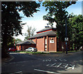
Stoney Lane off Church Road, Crystal Palace
A public lane leading to other paths through the Crystal Palace 'triangle'. Stoney Lane is home to a maker of ornamental ironwork; pleasing examples can be seen in the residential heart of the 'village'.
Image: © Robin Stott
Taken: 16 May 2022
0.02 miles
2
Stoney Lane meets Telford Close, in the Norwood triangle
The centre of the Upper Norwood triangle used to be given over to light industry: joinery, engineering and so forth. Some works survive, but much of it now is made up of small housing estates, various cul-de-sac lanes into the triangle giving onto a network of pedestrian paths. Stoney Lane leads in from the south and here meets Telford Close coming in from the east.
Image: © Christopher Hilton
Taken: 30 Dec 2010
0.02 miles
3
The Greek Orthodox Church of St Constantine & St Helen, SE19
At 69a Westow Street, Upper Norwood, London SE19
Image: © Philip Talmage
Taken: 8 Sep 2005
0.02 miles
4
Foresters Hall, Westow Street, Upper Norwood SE19
Westow Street is in the heart of the Upper Norwood Triangle Conservation Area. This building, together with the Orthodox church and a number of local pubs and shops, may be demolished only in very exceptional circumstances.
Image: © Philip Talmage
Taken: 7 Sep 2005
0.02 miles
5
Westow Street Community Centre, SE19
In the Upper Norwood Triangle Conservation Area.
Image: © Philip Talmage
Taken: 7 Sep 2005
0.02 miles
6
Paxton Mews, SE19
Paxton Mews, an area of workshops and small businesses, lies behind the shops on Westow Street.
Image: © Christopher Hilton
Taken: 26 Aug 2017
0.02 miles
7
Paxton Mews off Westow Street, Crystal Palace
One of the many narrow lanes, some interconnecting and public, some private like this, in the Crystal Palace 'triangle'.
Image: © Robin Stott
Taken: 16 May 2022
0.02 miles
8
Stoney Lane, looking into the Norwood triangle
The centre of the Upper Norwood triangle used to be given over to light industry: joinery, engineering and so forth. Some works survive, such as the art metal works in the middle distance here, but much of it now is made up of small housing estates, various cul-de-sac lanes into the triangle giving onto a network of pedestrian paths. Stoney Lane leads in from the south.
Image: © Christopher Hilton
Taken: 30 Dec 2010
0.03 miles
9
Paxton Mews, SE19
Paxton Mews, an area of workshops and small businesses, lies behind the shops on Westow Street.
Image: © Christopher Hilton
Taken: 26 Aug 2017
0.03 miles
10
Entrance to Greek Orthodox Church
Image: © Chris L L
Taken: 30 Dec 2008
0.03 miles


