IMAGES TAKEN NEAR TO
Bedwardine Road, LONDON, SE19 3AP
Introduction
This page details the photographs taken nearby to Bedwardine Road, SE19 3AP by members of the Geograph project.
The Geograph project started in 2005 with the aim of publishing, organising and preserving representative images for every square kilometre of Great Britain, Ireland and the Isle of Man.

There are currently over 7.5m images from over14,400 individuals and you can help contribute to the project by visiting https://www.geograph.org.uk
Image Map
Images are licensed for reuse under creativecommons.org/licenses/by-sa/2.0
Notes
- Clicking on the map will re-center to the selected point.
- The higher the marker number, the further away the image location is from the centre of the postcode.
Image Listing (331 Images Found)
Images are licensed for reuse under creativecommons.org/licenses/by-sa/2.0
Image
Details
Distance
1
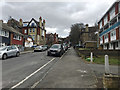
Northeast and uphill on Bedwardine Road, Upper Norwood, south London
Signed as a cul-de-sac, there is only a pedestrian connection with Haynes Lane. The area has a mixture of house-types of different periods.
Image: © Robin Stott
Taken: 23 Mar 2018
0.02 miles
2
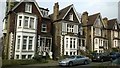
Victorian villas, Gatestone Road, SE19
Image: © Christopher Hilton
Taken: 21 Apr 2016
0.03 miles
3
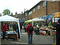
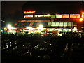
Crystal Palace Food Market
A Saturday market of various organic and artisan foods, taking place where Haynes Lane meets Bedwardine Road. The buildings on the right are part of a complex of workshops and second-hand shops that back onto the Sainsbury's development on Westow Street.
Image: © Christopher Hilton
Taken: 18 May 2013
0.04 miles
4
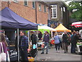
Crystal Palace Food Market
A Saturday market of various organic and artisan foods, taking place where Haynes Lane meets Bedwardine Road. The buildings on the left are part of a complex of workshops and second-hand shops that back onto the Sainsbury's development on Westow Street.
Image: © Christopher Hilton
Taken: 18 May 2013
0.04 miles
5
Westow Park
as viewed from car park at Sainsbury's supermarket
Image: © Chris L L
Taken: 13 Jan 2009
0.04 miles
6
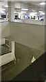
Upper Norwood Sainsbury's car park
The Upper Norwood Sainsbury's is built on top of a steep hill, with two layers of car-park set into the side of the hill below the supermarket.
Image: © Christopher Hilton
Taken: 10 Jan 2016
0.04 miles
7
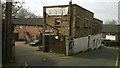
Workshops, Haynes Lane, SE19
Tucked off the Norwood triangle down Haynes Lane, an area of workshops below Sainsbury's recalls Norwood's history as a hub of light engineering; they are now used by artisans, craftsmen and women, and antique sellers.
The purpose of the tyrannosaurus, seen above the parked car, was unclear.
At the extreme right of the picture, the road turns through ninety degrees along the back of the workshops and, passing through barriers that stop vehicles, becomes Bedwardine Road.
Image: © Christopher Hilton
Taken: 21 Apr 2016
0.05 miles
9
Garden centre and supermarket car park, from Coxwell Road
The Secret Garden garden centre is tucked into the space between Sainsbury's (which sits atop a multistorey carpark) and the curving access road, Coxwell Road, that leads down from the plateau of the Crystal Palace hill. As can be seen, in mid-December when this was taken there were many Christmas trees already on display.
Image: © Christopher Hilton
Taken: 11 Dec 2010
0.05 miles
10
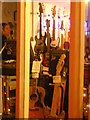
The Secret Guitar Shop, Bedwardine Road
Hayes Lane, which turns into Bedwardine Road, twists down off the Crystal Palace plateau and on the way gives access to various old light engineering premises now used for premises such as craft workshops, an antiques and second-hand market, and this guitar shop which is the last commercial outlet before one emerges into suburbia at the bottom of the hill. Taken after dark on a winter's evening.
I don't remember ever seeing a left-handed bass before; there's a niche market.
Image: © Christopher Hilton
Taken: 11 Dec 2010
0.05 miles