IMAGES TAKEN NEAR TO
Southholme Close, LONDON, SE19 2QU
Introduction
This page details the photographs taken nearby to Southholme Close, SE19 2QU by members of the Geograph project.
The Geograph project started in 2005 with the aim of publishing, organising and preserving representative images for every square kilometre of Great Britain, Ireland and the Isle of Man.

There are currently over 7.5m images from over14,400 individuals and you can help contribute to the project by visiting https://www.geograph.org.uk
Image Map
Images are licensed for reuse under creativecommons.org/licenses/by-sa/2.0
Notes
- Clicking on the map will re-center to the selected point.
- The higher the marker number, the further away the image location is from the centre of the postcode.
Image Listing (210 Images Found)
Images are licensed for reuse under creativecommons.org/licenses/by-sa/2.0
Image
Details
Distance
2

Stambourne Way - Steep Hill 13%
Stambourne Way, Crystal Palace. 13% steep hill down sign.
Image: © Adam Morse
Taken: 19 May 2009
0.06 miles
3
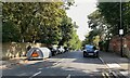
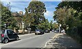
Stambourne Way, Upper Norwood
Church Road, behind the camera, runs along a ridge. Side roads are level for a short distance then traffic drops out of sight. The gradient here is greater than 10%.
Photo number 7649549.
Image: © Robin Stott
Taken: 3 Sep 2023
0.07 miles
4
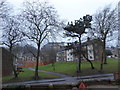
Sylvan Hill, Upper Norwood
Church Road, behind the camera, runs along a ridge. Side roads are level for a short distance then traffic drops out of sight. Busy.
Photo number 7649605.
Image: © Robin Stott
Taken: 3 Sep 2023
0.08 miles
5
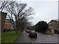
Twentieth-century flats, Church Road, Upper Norwood
The further along Church Road from the Crystal Palace 'triangle', the less the well-heeled Victorian character is evident.
Photo number 7649538.
Image: © Robin Stott
Taken: 3 Sep 2023
0.09 miles
6
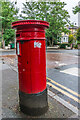
Victorian pillar box
Victorian pillar box in Sylvan Hill by its junction with Church Road.
Image: © Ian Capper
Taken: 6 Jul 2024
0.10 miles
7
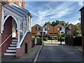
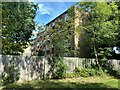
Woodview Mews, Church Road, Upper Norwood
Behind 273 and 275 Church Road is this 8-year old development of flats and houses; the six timber-clad frontages represent 11 dwellings. The side porch of 273 shows on the left. As I was framing a shot a local resident appeared and asked if I was an architectural photographer or a bailiff. Bailiffs in Upper Norwood? Who would have thought – but it was a period of suddenly high interest rates.
Photo number 7649646.
Image: © Robin Stott
Taken: 3 Sep 2023
0.10 miles
8
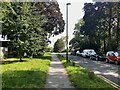
Sunday traffic, Church Road, Upper Norwood
Leafy Church Road runs along a ridge towards Crystal Palace.
Photo number 7649568.
Image: © Robin Stott
Taken: 3 Sep 2023
0.10 miles
9
Looking from St John's Churchyard across Auckland Road
Image: © Basher Eyre
Taken: 20 Jan 2018
0.10 miles
10
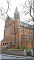
St.John, Upper Norwood
Attractive orange brick-built church.
Image: © Peter Trimming
Taken: 28 Feb 2009
0.11 miles