IMAGES TAKEN NEAR TO
Claybourne Mews, LONDON, SE19 2PW
Introduction
This page details the photographs taken nearby to Claybourne Mews, SE19 2PW by members of the Geograph project.
The Geograph project started in 2005 with the aim of publishing, organising and preserving representative images for every square kilometre of Great Britain, Ireland and the Isle of Man.

There are currently over 7.5m images from over14,400 individuals and you can help contribute to the project by visiting https://www.geograph.org.uk
Image Map
Images are licensed for reuse under creativecommons.org/licenses/by-sa/2.0
Notes
- Clicking on the map will re-center to the selected point.
- The higher the marker number, the further away the image location is from the centre of the postcode.
Image Listing (308 Images Found)
Images are licensed for reuse under creativecommons.org/licenses/by-sa/2.0
Image
Details
Distance
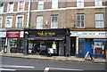
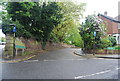
2
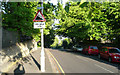
Fox Hill - Steep Hill 20%
Fox Hill, Crystal Palace. 20% steep hill down sign.
Image: © Adam Morse
Taken: 19 May 2009
0.03 miles
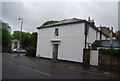
6
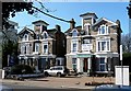
114 and 116 Church Road
A symmetrical (mirror image) pair of Italianate mid-C19th white brick houses. Each has a tower, that feature so beloved of Victorians, pierced by a pair of unusually tall and thin round-headed windows. As may be apparent, the house on the right is now a hotel.
Church Road has a number of good suburban villas dating from around this time, many of which have been converted to multiple occupancy or institutional use, and most of its buildings are within a Conservation Area.
Image: © Stephen Richards
Taken: Unknown
0.04 miles
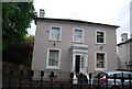
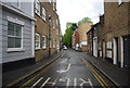
10
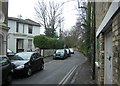
Lansdowne Place, Upper Norwood
This little road running diagonally away from the Norwood triangle carries the boundary between the London Boroughs of Bromley and Croydon (previously between the counties of Kent and Surrey respectively). Unusually, the boundary runs not down the middle of the road, but along the property frontages on the left of the road.
Image: © Christopher Hilton
Taken: 1 Jan 2011
0.04 miles