IMAGES TAKEN NEAR TO
Turkey Oak Close, LONDON, SE19 2NZ
Introduction
This page details the photographs taken nearby to Turkey Oak Close, SE19 2NZ by members of the Geograph project.
The Geograph project started in 2005 with the aim of publishing, organising and preserving representative images for every square kilometre of Great Britain, Ireland and the Isle of Man.

There are currently over 7.5m images from over14,400 individuals and you can help contribute to the project by visiting https://www.geograph.org.uk
Image Map
Images are licensed for reuse under creativecommons.org/licenses/by-sa/2.0
Notes
- Clicking on the map will re-center to the selected point.
- The higher the marker number, the further away the image location is from the centre of the postcode.
Image Listing (170 Images Found)
Images are licensed for reuse under creativecommons.org/licenses/by-sa/2.0
Image
Details
Distance
1
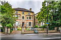
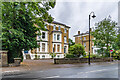
144 Church Road
Large 19th Century villa marked on the 1870 6" map.
Image: © Ian Capper
Taken: 6 Jul 2024
0.05 miles
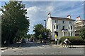
2
Church Road (1)
The junction with Upper Beulah Hill.
Image: © Robin Drayton
Taken: 24 Mar 2008
0.05 miles
3
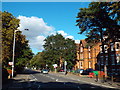
Sunday traffic, Church Road, Upper Norwood
Leafy Church Road runs along a ridge towards Crystal Palace.
Photo number 7649568.
Image: © Robin Stott
Taken: 3 Sep 2023
0.06 miles
4
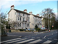
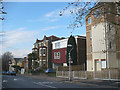
140 & 142 Church Road
Large pair of semi-detached 19th Century villas marked on the 1870 6" map. A green plaque by the door to no 140 (on the right) commemorates Admiral Robert Fitzroy. Fitzroy, pioneer of meteorology (including founding what later became the Met Office) and captain of the ship on which Charles Darwin voyaged to the Galapagos, HMS Beagle, lived here for the last month or so of his life. Suffering from depression, he committed suicide here on 30 April 1865.
Image: © Ian Capper
Taken: 6 Jul 2024
0.06 miles
5
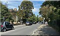
Highfield Hill
Mixed housing styles in Upper Norwood.
Image: © Robin Drayton
Taken: 24 Mar 2008
0.06 miles
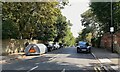
6
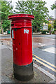
Victorian pillar box
Victorian pillar box in Sylvan Hill by its junction with Church Road.
Image: © Ian Capper
Taken: 6 Jul 2024
0.06 miles
7
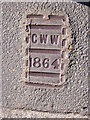
Croydon Waterworks cover, Church Road SE19
This metal cover, judging by its size, conceals a stopcock. 1864 is very early in the life of this suburb: the Crystal Palace had only recently moved to this hilltop site, provoking development in which villas were laid out around it.
Image: © Christopher Hilton
Taken: 18 Sep 2012
0.06 miles
8
Upper Beulah Hill, Upper Norwood
A cyclist (only one!) turns the corner into Church Road, which runs level along a ridge to the Crystal Palace 'triangle'. At weekends the area is heaving with cyclists – getting up here is a challenge for the legs and the gears. There are any number of steep climbs to choose from.
Photo number 7649672.
Image: © Robin Stott
Taken: 3 Sep 2023
0.07 miles
9
Sylvan Hill, Upper Norwood
Church Road, behind the camera, runs along a ridge. Side roads are level for a short distance then traffic drops out of sight. Busy.
Photo number 7649605.
Image: © Robin Stott
Taken: 3 Sep 2023
0.08 miles