IMAGES TAKEN NEAR TO
Maberley Crescent, LONDON, SE19 2JG
Introduction
This page details the photographs taken nearby to Maberley Crescent, SE19 2JG by members of the Geograph project.
The Geograph project started in 2005 with the aim of publishing, organising and preserving representative images for every square kilometre of Great Britain, Ireland and the Isle of Man.

There are currently over 7.5m images from over14,400 individuals and you can help contribute to the project by visiting https://www.geograph.org.uk
Image Map
Images are licensed for reuse under creativecommons.org/licenses/by-sa/2.0
Notes
- Clicking on the map will re-center to the selected point.
- The higher the marker number, the further away the image location is from the centre of the postcode.
Image Listing (239 Images Found)
Images are licensed for reuse under creativecommons.org/licenses/by-sa/2.0
Image
Details
Distance
1
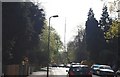
Hamlet Rd
The Croydon Transmitter is clearly seen.
Image: © N Chadwick
Taken: 9 Apr 2011
0.04 miles
3
20 & 22 Hamlet Road
Pair of semi-detached houses in Hamlet Road, with dates MDCCCL11 (1852) and MMXVII (2017) (presumably the building and restoration dates respectively). Grade II listed - see https://historicengland.org.uk/listing/the-list/list-entry/1359319?section=official-list-entry.
Image: © Ian Capper
Taken: 6 Jul 2024
0.06 miles
4
20 & 22 Hamlet Road
Pair of semi-detached houses in Hamlet Road, with dates MDCCCL11 (1852) and MMXVII (2017) (presumably the building and restoration dates respectively). Grade II listed - see https://historicengland.org.uk/listing/the-list/list-entry/1359319?section=official-list-entry.
Image: © Ian Capper
Taken: 6 Jul 2024
0.06 miles
5
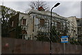
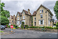
Decaying early nineteenth-century building, 20-22 Hamlet Road, Upper Norwood
This pair of semi-detached houses (which appear to pre-date much of the mid-nineteenth century Gothic development that followed the erection of the Crystal Palace) had been derelict for some years at the time of the picture. The buildings are grade II listed (https://historicengland.org.uk/advice/heritage-at-risk/search-register/list-entry/1378925 ).
The sign announced a sale by auction some three days prior to taking the photograph; it remains to be seen if this will lead to renovation or to demolition in order to squeeze in a block of flats.
Image: © Christopher Hilton
Taken: 24 Apr 2016
0.06 miles
6
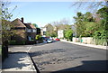
Maberley Rd
Belvedere Rd can be seen to the left.
Image: © N Chadwick
Taken: 9 Apr 2011
0.06 miles
7
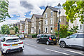
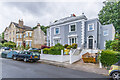
Belvedere Road
19th Century villas in Belvedere Road, marked on the 187o 6" map.
Image: © Ian Capper
Taken: 6 Jul 2024
0.08 miles
8
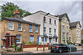
6 - 16 Hamlet Road
19th Century houses in Hamlet Road, marked on the 187o 6" map.
Image: © Ian Capper
Taken: 6 Jul 2024
0.08 miles
9
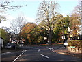
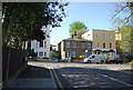
Road junction on Hamlet Road, Anerley
Hamlet Road leads from Anerley Road. Belvedere Road leads right up towards Church Road, Norwood or left down to Maberley Road. Auckland Road carries straight ahead towards South Norwood.
Image: © David Anstiss
Taken: 13 Nov 2011
0.09 miles
10
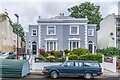
Belvedere Road
19th Century villas in Belvedere Road, marked on the 187o 6" map.
Image: © Ian Capper
Taken: 6 Jul 2024
0.09 miles