IMAGES TAKEN NEAR TO
Belvedere Road, LONDON, SE19 2HZ
Introduction
This page details the photographs taken nearby to Belvedere Road, SE19 2HZ by members of the Geograph project.
The Geograph project started in 2005 with the aim of publishing, organising and preserving representative images for every square kilometre of Great Britain, Ireland and the Isle of Man.

There are currently over 7.5m images from over14,400 individuals and you can help contribute to the project by visiting https://www.geograph.org.uk
Image Map
Images are licensed for reuse under creativecommons.org/licenses/by-sa/2.0
Notes
- Clicking on the map will re-center to the selected point.
- The higher the marker number, the further away the image location is from the centre of the postcode.
Image Listing (176 Images Found)
Images are licensed for reuse under creativecommons.org/licenses/by-sa/2.0
Image
Details
Distance
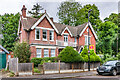
1
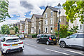
Belvedere Road
19th Century villas in Belvedere Road, marked on the 187o 6" map.
Image: © Ian Capper
Taken: 6 Jul 2024
0.03 miles
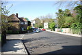
2
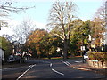
Road junction on Hamlet Road, Anerley
Hamlet Road leads from Anerley Road. Belvedere Road leads right up towards Church Road, Norwood or left down to Maberley Road. Auckland Road carries straight ahead towards South Norwood.
Image: © David Anstiss
Taken: 13 Nov 2011
0.05 miles
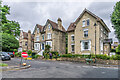
3
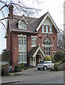
136 Auckland Road
One of a group of substantial houses on this road with impressive Gothic staircase windows. They were designed by C.J.C Pawley, c1883.
Image: © Stephen Richards
Taken: Unknown
0.05 miles
4
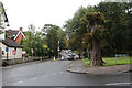
Auckland Road
A car negotiates a width restriction as it approaches the junction with Belvedere Road.
Image: © Martin Addison
Taken: 13 Sep 2013
0.05 miles
5
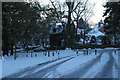
Fox Hill: the green at the bottom of the hill, in snow
Image: © Christopher Hilton
Taken: 3 Dec 2010
0.06 miles
6

Houses overlooking small green on Belvedere Road
In an area with some very fine (and large) Victorian villas.
Image: © David Martin
Taken: 30 Oct 2022
0.06 miles
7
Maberley Rd
Belvedere Rd can be seen to the left.
Image: © N Chadwick
Taken: 9 Apr 2011
0.06 miles
8
Belvedere Road
19th Century villas in Belvedere Road, marked on the 187o 6" map.
Image: © Ian Capper
Taken: 6 Jul 2024
0.07 miles
9
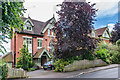
134 & 136 Auckland Road
1880s houses in Auckland Road, designed by Charles J C Pawley.
Image: © Ian Capper
Taken: 6 Jul 2024
0.07 miles
10
167 Auckland Road
House in Auckland Road, first marked on the 1896 1:1056 plan.
Image: © Ian Capper
Taken: 6 Jul 2024
0.07 miles