IMAGES TAKEN NEAR TO
Belvedere Road, LONDON, SE19 2HX
Introduction
This page details the photographs taken nearby to Belvedere Road, SE19 2HX by members of the Geograph project.
The Geograph project started in 2005 with the aim of publishing, organising and preserving representative images for every square kilometre of Great Britain, Ireland and the Isle of Man.

There are currently over 7.5m images from over14,400 individuals and you can help contribute to the project by visiting https://www.geograph.org.uk
Image Map
Images are licensed for reuse under creativecommons.org/licenses/by-sa/2.0
Notes
- Clicking on the map will re-center to the selected point.
- The higher the marker number, the further away the image location is from the centre of the postcode.
Image Listing (263 Images Found)
Images are licensed for reuse under creativecommons.org/licenses/by-sa/2.0
Image
Details
Distance
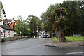
1
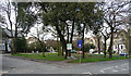
Belvedere Road (2)
Belvedere Road is the other side of the greenery. Auckland Road is in the foreground, and Fox Hill off to the left.
Next to the blue sign is a Bromley sign, the photo being taken from Croydon.
Image: © Stephen Richards
Taken: Unknown
0.01 miles
2
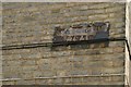
Waldegrave Road SE19: misspelled roadsign
This old street sign gives the name as Waldergrave Road, adding a superfluous R.
Image: © Christopher Hilton
Taken: 6 Apr 2009
0.02 miles
3
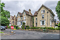
Belvedere Road
19th Century villas in Belvedere Road, marked on the 187o 6" map.
Image: © Ian Capper
Taken: 6 Jul 2024
0.02 miles
4

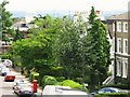
Houses overlooking small green on Belvedere Road
In an area with some very fine (and large) Victorian villas.
Image: © David Martin
Taken: 30 Oct 2022
0.03 miles
5
Belvedere Road, SE19
Shows the location of Image Also perhaps indicates why the road is so called - above and beyond the rooftops one can just make out through the murk a panorama of a large part of southeast London.
Image: © Mike Quinn
Taken: 4 Jul 2008
0.03 miles
6
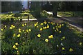
Fox Hill: the green at the bottom of the hill
This little green patch can look a little tired at times, with fly-tippers and dog-walkers a problem; but every spring a glorious display of daffodils appears.
The same green can be seen also in spring at Image and in snow at Image
Image: © Christopher Hilton
Taken: 4 Apr 2010
0.03 miles
7
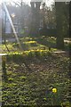
Fox Hill: the green at the bottom of the hill
The roads along the side of this green are subject to a seven-foot width restriction to prevent lorry traffic using the Auckland Road - Hamlet Road route; recently, wooden bollards have been fitted across the green to prevent lorries that arrive at the width restriction from swerving over the green to get by it.
The same green can be seen also in spring at Image and in snow at Image
Image: © Christopher Hilton
Taken: 4 Apr 2010
0.03 miles
8
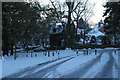
Fox Hill: the green at the bottom of the hill, in snow
Image: © Christopher Hilton
Taken: 3 Dec 2010
0.04 miles
9
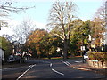
Road junction on Hamlet Road, Anerley
Hamlet Road leads from Anerley Road. Belvedere Road leads right up towards Church Road, Norwood or left down to Maberley Road. Auckland Road carries straight ahead towards South Norwood.
Image: © David Anstiss
Taken: 13 Nov 2011
0.04 miles
10
Auckland Road
A car negotiates a width restriction as it approaches the junction with Belvedere Road.
Image: © Martin Addison
Taken: 13 Sep 2013
0.05 miles