IMAGES TAKEN NEAR TO
Church Road, LONDON, SE19 2EL
Introduction
This page details the photographs taken nearby to Church Road, SE19 2EL by members of the Geograph project.
The Geograph project started in 2005 with the aim of publishing, organising and preserving representative images for every square kilometre of Great Britain, Ireland and the Isle of Man.

There are currently over 7.5m images from over14,400 individuals and you can help contribute to the project by visiting https://www.geograph.org.uk
Image Map
Images are licensed for reuse under creativecommons.org/licenses/by-sa/2.0
Notes
- Clicking on the map will re-center to the selected point.
- The higher the marker number, the further away the image location is from the centre of the postcode.
Image Listing (568 Images Found)
Images are licensed for reuse under creativecommons.org/licenses/by-sa/2.0
Image
Details
Distance
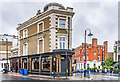
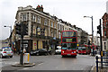
1
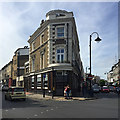
Corner of Church Road and Westow Hill, Upper Norwood, southeast London
Busy Church Road is on the left. The corner building is the closed Cambridge pub, now in the hands of Pedder Development Consultancy. The circular feature on the roof is seen in a 2015 photo: Image but not in 2011 for example: Image There are two signs on a photo of 2013: Sold, and Courage Fine Ales.
Image: © Robin Stott
Taken: 26 Aug 2017
0.00 miles
2
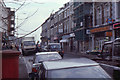
Westow Hill, SE19, January 2000
At this time the three roads of the Upper Norwood triangle were all two-way: the triangle turned into a one-way system two or three years after this. At the same time, the roundabout at the top of Anerley Hill, seen on the distant direction sign, became a crossroads controlled by traffic lights.
Image: © Christopher Hilton
Taken: 26 Jan 2000
0.00 miles
3
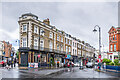
Westow Hill
Looking along Westow Hill. On the left is the former Cambridge, a late 19th Century pub at the junction with Church Road and Westow Hill. Following closure in 2011 and long term disuse, it reopened as a restaurant, Cocos, in early 2024. On the far right is Bank Chambers, 77 Westow Hill, with a date plaque of 1884. Formerly a branch of the NatWest Bank, it now houses the offices of a firm of solicitors.
Image: © Ian Capper
Taken: 6 Jul 2024
0.01 miles
5
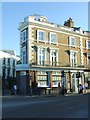
Norwood
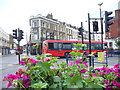
Busy suburban crossroads in South London where four roods meet on the hilltop: Anerley Hill, Church Road, Westow Hill and Crystal Palace Parade. The large building in the centre is The Cambridge pub. Geraniums and petunias in boxes on top of railings brighten up the scene.
Image: © Colin Smith
Taken: 13 Jun 2009
0.01 miles
6
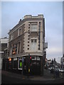
Upper Norwood: The Cambridge
Tucked into a wedge-shaped site at one point of the Norwood triangle, one of several pubs that cluster round the junction (once known as the Vicar's Oak) at the south end of Crystal Palace Parade.
Image: © Christopher Hilton
Taken: 25 Jan 2011
0.01 miles
7
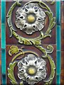
Upper Norwood: detail of tiles on The Cambridge pub
Classic late nineteenth century ornamental tiles, seen on many pubs of that age.
Image: © Christopher Hilton
Taken: 28 Jun 2008
0.01 miles
8
The Cambridge
Late 19th Century former pub at the junction of Church Road and Westow Hill. Following closure in 2011 and long term disuse, it reopened as a restaurant, Cocos, in early 2024. In the right background is Bank Chambers, 77 Westow Hill, with a date plaque of 1884. Formerly a branch of the NatWest Bank, it now houses the offices of a firm of solicitors.
Image: © Ian Capper
Taken: 6 Jul 2024
0.01 miles
9
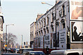
Crystal Palace: former Palace Hotel, Church Road, 1993
I took this picture in 1993 because the hoardings appearing around the former Palace Hotel (and the closure of the little shops on the ground floor) suggested that it might soon be demolished. In fact, it has subsequently been redeveloped and shops (and a Chinese restaurant) once again occupy the ground floor, with flats (still not particularly swish) on the floors above.
Notice the traffic in the foreground heading northwards: since the early 2000s the roads in the Crystal Palace Triangle have been one-way and only southbound traffic uses this street.
The distant zebra crossings mark the roads entering the roundabout that at this time controlled the junction at the top of Anerley Hill - this is now (2012) a crossroads controlled by traffic lights.
Image: © Christopher Hilton
Taken: 28 Nov 1993
0.01 miles
10
Top of the Hill
A 432 Bus crosses Crystal Palace Parade, at the summit of the Sydenham Hill ridge, after climbing Westow Hill to begin the descent of Anerley Hill. On the left is The Cambridge public house which is currently closed - whether the To Let signs will attract a new owner remains to be seen.
Image: © Martin Addison
Taken: 13 Sep 2013
0.02 miles