IMAGES TAKEN NEAR TO
Belvedere Road, LONDON, SE19 2AT
Introduction
This page details the photographs taken nearby to Belvedere Road, SE19 2AT by members of the Geograph project.
The Geograph project started in 2005 with the aim of publishing, organising and preserving representative images for every square kilometre of Great Britain, Ireland and the Isle of Man.

There are currently over 7.5m images from over14,400 individuals and you can help contribute to the project by visiting https://www.geograph.org.uk
Image Map
Images are licensed for reuse under creativecommons.org/licenses/by-sa/2.0
Notes
- Clicking on the map will re-center to the selected point.
- The higher the marker number, the further away the image location is from the centre of the postcode.
Image Listing (359 Images Found)
Images are licensed for reuse under creativecommons.org/licenses/by-sa/2.0
Image
Details
Distance
2
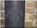
Boundary marker, Lansdowne Place, Upper Norwood
This little road running diagonally away from the Norwood triangle carries the boundary between the London Boroughs of Bromley and Croydon (previously between the counties of Kent and Surrey respectively). Unusually, the boundary runs not down the middle of the road, but along the property frontages on the north side of the road. The metal boundary post shown here carries the writing "Battersea 1854": at this time the land on the Kent side of the boundary (in this photograph, the building), later the Urban District of Penge, was a detached portion of the parish of Battersea, whilst that in which the photographer is standing was part of the parish of Croydon.
Image: © Christopher Hilton
Taken: 1 Jan 2011
0.01 miles
3
Boundary marker, Lansdowne Place, Upper Norwood
This little road running diagonally away from the Norwood triangle carries the boundary between the London Boroughs of Bromley and Croydon (previously between the counties of Kent and Surrey respectively). Unusually, the boundary runs not down the middle of the road, but along the property frontages on the north side of the road. The metal boundary post shown here carries the writing "Battersea 1854": at this time the land on the Kent side of the boundary (in this photograph, the building), later the Urban District of Penge, was a detached portion of the parish of Battersea, whilst that in which the photographer is standing was part of the parish of Croydon.
Image: © Christopher Hilton
Taken: 1 Jan 2011
0.01 miles
4
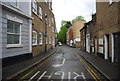
Lansdowne Place, Upper Norwood
This little road running diagonally away from the Norwood triangle carries the boundary between the London Boroughs of Bromley and Croydon (previously between the counties of Kent and Surrey respectively). Unusually, the boundary runs not down the middle of the road, but along the property frontages on the right of the road.
Image: © Christopher Hilton
Taken: 1 Jan 2011
0.01 miles
5
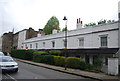
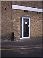
11 - 25, Belvedere Rd
Grade II listed terrace. http://www.britishlistedbuildings.co.uk/en-358338-11-25-belvedere-road-se-19-greater-londo
Image: © N Chadwick
Taken: 11 May 2013
0.03 miles
6
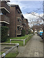
Kendall Court flats, on the west side of Tudor Road, Upper Norwood, south London
They first appear on a map of 1983-93. The site was mainly of a works that had expanded into a street of Victorian semi-detached villas. The bold concrete elements recall Basil Spence's University of Sussex.
Image: © Robin Stott
Taken: 23 Mar 2018
0.03 miles
7
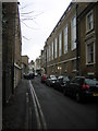
Almshouses in Belvedere Road, SE19
I'll admit that at the time of taking the photograph it didn't occur to me that the dwellings in the long low terrace might be almshouses - I learnt that later, from the Listing: http://www.britishlistedbuildings.co.uk/en-358338-11-25-belvedere-road-se-19-greater-londo
The listing suggests a date of about 1850, which (without knowing the detailed history of the area) is later than I might have guessed. I noticed the 'label moulds' - little hoods (with drop-ends) - over the first-floor windows. That seemed to me a 'Gothick' feature - more typical of the Gothic revival of the early decades of the 19th century. The design of the ground-floor windows (sorry, hidden behind the hedge) confirms the Gothick impression.
But - for whatever reason - the design of almshouses often lagged generations behind mainstream fashion. So perhaps 1850 is as likely a date as any.
Label moulds can be seen more clearly in my photo of the Langland almshouses in Henley - known to date from 1830: http://www.geograph.org.uk/photo/3066061
Image: © Stefan Czapski
Taken: 11 Feb 2015
0.03 miles
10
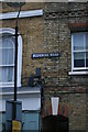
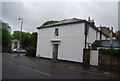
Victorian street sign, Belvedere Road SE19
Image: © Christopher Hilton
Taken: 10 Mar 2013
0.03 miles