IMAGES TAKEN NEAR TO
Westow Hill, LONDON, SE19 1TW
Introduction
This page details the photographs taken nearby to Westow Hill, SE19 1TW by members of the Geograph project.
The Geograph project started in 2005 with the aim of publishing, organising and preserving representative images for every square kilometre of Great Britain, Ireland and the Isle of Man.

There are currently over 7.5m images from over14,400 individuals and you can help contribute to the project by visiting https://www.geograph.org.uk
Image Map
Images are licensed for reuse under creativecommons.org/licenses/by-sa/2.0
Notes
- Clicking on the map will re-center to the selected point.
- The higher the marker number, the further away the image location is from the centre of the postcode.
Image Listing (411 Images Found)
Images are licensed for reuse under creativecommons.org/licenses/by-sa/2.0
Image
Details
Distance
1
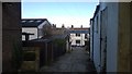
Cooper's Yard, SE19
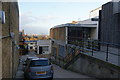
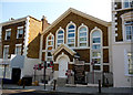
Cooper's Yard is a cul-de-sac descending northwards off Westow Hill, one of the sides of the Upper Norwood triangle. It houses first the Upper Norwood Methodist Church (see Image) then, further down, an area of workshops used by artists and artisans.
Image: © Christopher Hilton
Taken: 24 Dec 2014
0.01 miles
2
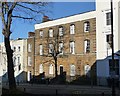
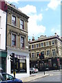
Former police station, Gipsy Hill
The Survey of London records that it was designed by "Charles Reeves, Metropolitan Police Surveyor, and erected in 1854 at a cost of £2,461. It was converted for use as police flats in 1948." I'm not sure it now has any connection with the police.
Image: © Stephen Richards
Taken: Unknown
0.01 miles
3
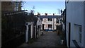
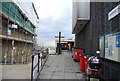
Cooper's Yard, SE19
Cooper's Yard is a cul-de-sac descending northwards off Westow Hill, one of the sides of the Upper Norwood triangle. It houses first the Upper Norwood Methodist Church (see Image) then, further down, an area of workshops used by artists and artisans.
Image: © Christopher Hilton
Taken: 24 Dec 2014
0.01 miles
4
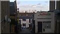
Cooper's Yard, SE19
Cooper's Yard is a cul-de-sac descending northwards off Westow Hill, one of the sides of the Upper Norwood triangle. It houses first the Upper Norwood Methodist Church (see Image: visible creeping into the top right of this image) then, further down, an area of workshops used by artists and artisans. From the upper end of the yard there are expansive views north to central London.
Image: © Christopher Hilton
Taken: 24 Dec 2014
0.01 miles
5
Upper Norwood Methodist Church
The church is tucked away down a side street, but from the street there are views of central London.
Image: © Bill Boaden
Taken: 1 Feb 2014
0.01 miles
6
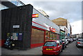
The Hollybush
Large Victorian building on Westow Hill at the top of Gipsy Hill, Norwood.
Image: © Colin Smith
Taken: 13 Jun 2009
0.02 miles
9
Gipsy Hill: former chapel
Appropriately, this former chapel on Gipsy Hill is being used as offices by a firm specialising in such conversions.
Image: © Dr Neil Clifton
Taken: 26 Jul 2012
0.03 miles
10
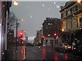
Upper Norwood: hailstorm on Westow Street
Beyond the traffic lights, the pale horizon beyond the storm highlights the converted tower of Christ Church Gipsy Hill, and beyond that the skyscrapers of central London.
Image: © Christopher Hilton
Taken: 21 Mar 2008
0.03 miles