IMAGES TAKEN NEAR TO
Farquhar Road, LONDON, SE19 1SS
Introduction
This page details the photographs taken nearby to Farquhar Road, SE19 1SS by members of the Geograph project.
The Geograph project started in 2005 with the aim of publishing, organising and preserving representative images for every square kilometre of Great Britain, Ireland and the Isle of Man.

There are currently over 7.5m images from over14,400 individuals and you can help contribute to the project by visiting https://www.geograph.org.uk
Image Map
Images are licensed for reuse under creativecommons.org/licenses/by-sa/2.0
Notes
- Clicking on the map will re-center to the selected point.
- The higher the marker number, the further away the image location is from the centre of the postcode.
Image Listing (509 Images Found)
Images are licensed for reuse under creativecommons.org/licenses/by-sa/2.0
Image
Details
Distance
1
Water supply ? stop valve cover, Farquhar Road, Upper Norwood
Outside No 27, bearing only a W.
Image: © Robin Stott
Taken: 8 Oct 2018
0.01 miles
2
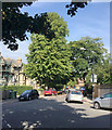
Garden fence, Jasper Road, Crystal Palace, south London
The houses are descending Farquhar Road. Crystal Palace village centre is on a summit. Approaches to it are surprisingly steep, and this spur of Jasper Road is no exception. The gradient is estimated as 1 in 5 in old money.
Image: © Robin Stott
Taken: 28 Aug 2017
0.02 miles
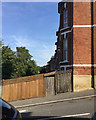
4
Outdoor surfaces, Bowley Close Regional Rehabilitation Centre, Upper Norwood, London
A number of surfaces have been laid for people learning to walk again – grass, gravel, boards, slabs, cobbles – with steps, slopes and handrails. Judging by a sign, the Centre is operated by Guy's and St Thomas' NHS Foundation Trust, with credit to King's Health Partners; the small print says 'An Academic Health Sciences Centre for London' and 'Pioneering better health for all'. The Centre and other developments are on the site of the Crystal Palace High Level station. More partial views: Image and Image This view is from Farquhar Road.
Image: © Robin Stott
Taken: 27 Aug 2017
0.02 miles
5
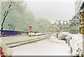
Snowstorm, Norwood 1981
View southward near top of Farquhar Road towards Crystal Palace Parade.
Image: © Ben Brooksbank
Taken: 11 Dec 1981
0.03 miles
6
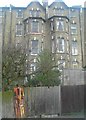
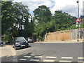
Site of Crystal Palace High Level station, from Crystal Palace Parade
Crystal Palace High Level station was built by the London, Chatham and Dover Railway, competing with the earlier Low Level station built by the London, Brighton and South Coast Railway; it was at the end of a branch from which a line ran north towards Nunhead and Peckham Rye. The line was closed in the early 1950s. Although its dead-end position ultimately doomed it, the High Level station had some advantages: it was much closer to the settlement that had grown up around the Palace, and much closer to the Palace itself. Steps led from the station to a subway under the Parade and thus directlly into the Palace: the brick platform in the foreground is the point to which stairs would climb and the subway (still extant) ran from about the bottom-left corner of the photograph behind the photographer.
In the background, terraced housing on Farquhar Road.
Image: © Christopher Hilton
Taken: 3 Jun 2011
0.03 miles
7
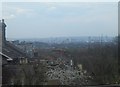
Jasper Road, SE19: view over the rooftops to the city
Image: © Christopher Hilton
Taken: 10 Apr 2008
0.03 miles
8
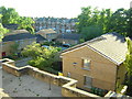
Jasper Road, SE19: view up to the backs of houses in Farquhar Road
Image: © Christopher Hilton
Taken: 10 Apr 2008
0.04 miles
9
Northwest and downhill on Jasper Road, Crystal Palace, south London
Crystal Palace village is on a summit. All the approaches are steep. The camera position is close to that for Image
Image: © Robin Stott
Taken: 28 Aug 2017
0.04 miles
10
Precipitous double-dogleg Jasper Road, Upper Norwood, south London
On the right are the backs of houses in Farquhar Road. A short spur of Jasper Road climbs steeply to meet Image Jasper Road continues steeply uphill behind the camera to meet Westow Hill Image It meets up with Farquhar Road again downhill.
Image: © Robin Stott
Taken: 14 Jul 2018
0.04 miles