IMAGES TAKEN NEAR TO
Thorsden Way, LONDON, SE19 1RA
Introduction
This page details the photographs taken nearby to Thorsden Way, SE19 1RA by members of the Geograph project.
The Geograph project started in 2005 with the aim of publishing, organising and preserving representative images for every square kilometre of Great Britain, Ireland and the Isle of Man.

There are currently over 7.5m images from over14,400 individuals and you can help contribute to the project by visiting https://www.geograph.org.uk
Image Map
Images are licensed for reuse under creativecommons.org/licenses/by-sa/2.0
Notes
- Clicking on the map will re-center to the selected point.
- The higher the marker number, the further away the image location is from the centre of the postcode.
Image Listing (136 Images Found)
Images are licensed for reuse under creativecommons.org/licenses/by-sa/2.0
Image
Details
Distance
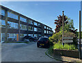
2
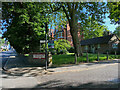
Charters Close off Gipsy Hill, Norwood, south London
The area has a wide range of housing, from Victorian villas to postwar blocks of flats, all in spacious surroundings.
Image: © Robin Stott
Taken: 6 Mar 2020
0.04 miles
3
Charters Close. Gipsy Hill, London
Another view is Image
Image: © Robin Stott
Taken: 14 May 2022
0.05 miles
4
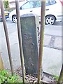
Old Boundary Marker by Gipsy Hill, Camberwell and Dulwich parish
Parish Boundary Marker by the UC road, in parish of Camberwell and Dulwich (Southwark District), Gipsy Hill SE19, opposite Grazeley Court flats, against park railings.
Inscription on East face reads:-
ST.
G.C
1874
(St Giles - Camberwell)
Surveyed
Milestone Society National ID: SY_SGC03pb
Image: © Milestone Society
Taken: Unknown
0.06 miles
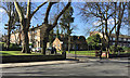
5
Entry to Charters Close, Gipsy Hill, London
Just up Gipsy Hill there is a row of four- and five-storey red brick mansions, partly visible here.
Image: © Robin Stott
Taken: 14 May 2022
0.06 miles
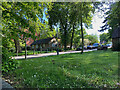
6
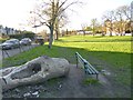
Gipsy Hill, Long Meadow
Park off Gipsy Hill, with a local reputation to contain a plague pit. http://www.addiscombe.net/tboa/news/2002/2002_05_29_01.htm
Image: © Mike Faherty
Taken: 20 Apr 2013
0.06 miles
7
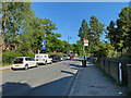
Bus stops C and H, Gipsy Hill, London
For service 322 to and from Crystal Palace up on the hill. Across the road is the public open space currently known as Long Meadow Image
Image: © Robin Stott
Taken: 14 May 2022
0.08 miles
9
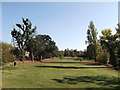
Gipsy Hill Gardens
Open Space area, as seen from Image
On the left is Dulwich Wood Avenue and on the right is Gipsy Hill.
Image: © David Anstiss
Taken: 2 Oct 2011
0.09 miles
10
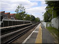
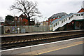
West end of Gipsy Hill station
Looking towards West Norwood and London Victoria (and, via a somewhat roundabout route, London Bridge).
Image: © Richard Vince
Taken: 14 May 2016
0.09 miles