IMAGES TAKEN NEAR TO
Gipsy Hill, LONDON, SE19 1QG
Introduction
This page details the photographs taken nearby to Gipsy Hill, SE19 1QG by members of the Geograph project.
The Geograph project started in 2005 with the aim of publishing, organising and preserving representative images for every square kilometre of Great Britain, Ireland and the Isle of Man.

There are currently over 7.5m images from over14,400 individuals and you can help contribute to the project by visiting https://www.geograph.org.uk
Image Map
Images are licensed for reuse under creativecommons.org/licenses/by-sa/2.0
Notes
- Clicking on the map will re-center to the selected point.
- The higher the marker number, the further away the image location is from the centre of the postcode.
Image Listing (346 Images Found)
Images are licensed for reuse under creativecommons.org/licenses/by-sa/2.0
Image
Details
Distance
1
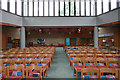
Gipsy Hill: All Saints Church
Showing the modern part of the church. The tower is to the right, see Image
Image: © Dr Neil Clifton
Taken: 26 Jul 2012
0.01 miles
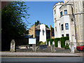
2
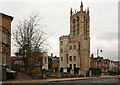
Gipsy Hill: Tower of Christ Church
Only the tower remains of the original ragstone church, the rest having been replaced by modern accommodation.
Image: © Dr Neil Clifton
Taken: 26 Jul 2012
0.01 miles
3
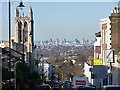
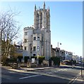
View down Gipsy Hill
One of the highest points in London so excellent vistas can be glimpsed between almost any two buildings or at any corner you turn in this area.
The tower on the left used to belong to Christ Church (1867, by John Giles), but is now a private residence after the remainder of the original church was destroyed by fire in 1982 (since rebuilt). Grade II listed.
The prominent buildings in the middle-distance, above the green building, are those of Dulwich College.
In the background a number of prominent buildings in the City are visible. To the left of the church is the dome of St Paul's Cathedral. To its right can be seen the three Barbican towers - Cromwell, Shakespeare, and Lauderdale (1965-76, Chamberlin, Powell and Bon). To the right the distinctive concrete tower is that of Guy's Hospital, the tallest hospital building in the world (1974, Watkins Gray).
Image: © Stephen Richards
Taken: Unknown
0.01 miles

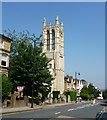
6
Gipsy Hill, Christ Church
The original parish church, partially destroyed by fire in 1987. The building appears to have been converted for residential use, and the current church is to the left, out of sight. http://www.gipsyhill.org.uk/
Image: © Mike Faherty
Taken: 20 Apr 2013
0.01 miles
7
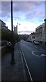
Winter morning view down Gipsy Hill, SE19
In the middle distance, the former tower of Christ Church Gipsy Hill, now converted to residential use. In the distance the towers of central London, the Shard bestriding the city with its customary blatancy. See Image for the view before the Shard was visited upon the horizon.
Image: © Christopher Hilton
Taken: 19 Dec 2014
0.01 miles
8
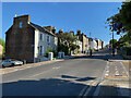
Gipsy Hill, Norwood ? going on up
On the left is the junction with Woodland Hill and on the right with Highland Road.
Image: © Robin Stott
Taken: 14 May 2022
0.01 miles