IMAGES TAKEN NEAR TO
Woodland Road, LONDON, SE19 1NT
Introduction
This page details the photographs taken nearby to Woodland Road, SE19 1NT by members of the Geograph project.
The Geograph project started in 2005 with the aim of publishing, organising and preserving representative images for every square kilometre of Great Britain, Ireland and the Isle of Man.

There are currently over 7.5m images from over14,400 individuals and you can help contribute to the project by visiting https://www.geograph.org.uk
Image Map (Loading...)


Getting Data...Please wait
Leaflet Map data © OpenStreetMap
Images are licensed for reuse under creativecommons.org/licenses/by-sa/2.0
Notes
- Clicking on the map will re-center to the selected point.
- The higher the marker number, the further away the image location is from the centre of the postcode.
Image Listing (486 Images Found)
Images are licensed for reuse under creativecommons.org/licenses/by-sa/2.0
Image
Details
Distance
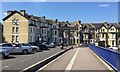
1
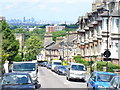
Woodland Road
Norwood street of Victorian terraced housing descending from Westow Hill. On the skyline is the City of London.
Image: © Colin Smith
Taken: 13 Jun 2009
0.02 miles
2
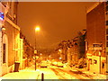
Snowy night, Woodland Road SE19
In the distance beyond the streetlight, you can just make out the office blocks in the City of London.
The snow that fell on this day (30th November 2010) was the start of a cold spell that saw snow lying through much of December.
Image: © Christopher Hilton
Taken: 30 Nov 2010
0.02 miles
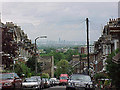
3
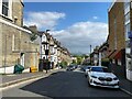
Woodland Road, Crystal Palace
The steep streets running north from Westow Hill enjoy a breathtaking view to the Shard and the City of London, over ten kilometres distant.
Photo number 7606587.
Image: © Robin Stott
Taken: 25 May 2023
0.02 miles
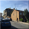
4
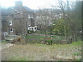
Jasper Road, SE19: view down into back gardens of Woodland Road
Image: © Christopher Hilton
Taken: 10 Apr 2008
0.03 miles
5
Top end of Farquhar Road, Upper Norwood, south London
The bridge is modern, probably built between 1984 and 1993 according to old OS maps. This was the period when the site of the Crystal Palace High Level station was redeveloped (out of shot right). Joining Crystal Palace Parade the original bridge spanned the south end of the station, believed to have been built at the time the enlarged Crystal Palace moved to south London in 1854. The Farquhar Road houses first appear on a map of 1894; in 1875 the land was shown as Brick Field. The houses are 3-storey at street level with a basement that, on steeply falling ground, is above garden level at the rear. Some have been divided into flats.
Image: © Robin Stott
Taken: 27 Aug 2017
0.03 miles
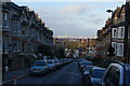
6
View of London from Crystal Palace
Looking down Woodland Road from Westow Hill showing the city some seven miles away.
Image: © Tony Wheeler
Taken: 30 May 2002
0.03 miles
7
Woodland Road, Crystal Palace
A residential road offering views of the City of London.
Image: © Bill Boaden
Taken: 1 Feb 2014
0.03 miles


10
South end of Jasper Road, Crystal Palace, south London
It climbs steeply to join Westow Hill. You walk s-l-o-w-l-y. One of the masts in Image can be seen top centre.
Image: © Robin Stott
Taken: 28 Aug 2017
0.05 miles