IMAGES TAKEN NEAR TO
Burntwood View, LONDON, SE19 1LG
Introduction
This page details the photographs taken nearby to Burntwood View, SE19 1LG by members of the Geograph project.
The Geograph project started in 2005 with the aim of publishing, organising and preserving representative images for every square kilometre of Great Britain, Ireland and the Isle of Man.

There are currently over 7.5m images from over14,400 individuals and you can help contribute to the project by visiting https://www.geograph.org.uk
Image Map
Images are licensed for reuse under creativecommons.org/licenses/by-sa/2.0
Notes
- Clicking on the map will re-center to the selected point.
- The higher the marker number, the further away the image location is from the centre of the postcode.
Image Listing (525 Images Found)
Images are licensed for reuse under creativecommons.org/licenses/by-sa/2.0
Image
Details
Distance
1
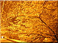
Snowy night, Crystal Palace Parade
Over the wall and some distance down, the housing estate built on the site of the former Crystal Palace High Level station (Image).
The snow that fell on this day (30th November 2010) was the start of a cold spell that saw snow lying through much of December.
Image: © Christopher Hilton
Taken: 30 Nov 2010
0.02 miles
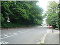
3
Crystal Palace Park
By Crystal Palace Parade on the right. The palace was erected on the levelled area to the left, its long axis parallel to the road.
Image: © Robin Webster
Taken: 23 Jul 2011
0.03 miles
4
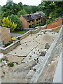
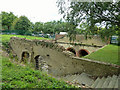
Crystal Palace (High Level) pedestrian subway
Looking down from Crystal Palace Parade at the visible remains at the station end of the subway under the road through to the Palace itself. The terrace is at the floor level of the subway. There was still some considerable climb required via steps up from the station platform level, the tracks being at the street level of the houses below. All traces of such steps and the station itself have been swept away, with housing and a medical centre on the site.
Image: © Robin Webster
Taken: 23 Jul 2011
0.03 miles
5
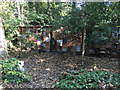
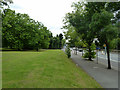
Conservation Volunteers? base, Dulwich Upper Wood, Farquhar Road, Upper Norwood
The wall incorporates what I believe are mini-habitats for insects and other small creatures.
Facebook: /dulwichupper.wood
Twitter: @dulwichuwood
The Conservation Volunteers: www.tcv.org.uk
Image: © Robin Stott
Taken: 10 Oct 2018
0.04 miles
6

The subway, Crystal Palace Park
A subway formerly ran from Crystal Palace High Level Station (off the left of the picture) under Crystal Palace Parade (the road on the left side of the photo) and into the Palace. The space seen here shows the point at which it emerged from the road into the Palace. The vaulted brick passages under the road survive and can be visited as part of a guided group.
Image: © Christopher Hilton
Taken: 2 Jun 2013
0.04 miles
7
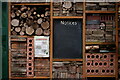
Giant Bug Hotel
Part of the structure on the side of the office in Dulwich Upper Wood, which is a 2.4 hectare local nature reserve.
Image: © Peter Trimming
Taken: 4 Jan 2022
0.04 miles
8
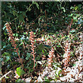
Broomrape among ivy, Dulwich Upper Wood, London
Broomrape (Orobanche species) is a parasitic plant, here probably on the roots of ivy. Dulwich Upper Wood is a Local Nature Reserve.
Image: © Robin Stott
Taken: 6 Aug 2022
0.04 miles
9
Crystal Palace High Level subway
The remains of the subway passing under Crystal Palace Parade and once connecting the High Level station with the palace itself. The subway is apparently ornately vaulted and in good condition. It is entered via four arches, only the centre two are visible here. Between the crumbling near wall and the subway was a concourse protected by a double pitched glass roof.
Image: © Robin Webster
Taken: 23 Jul 2011
0.04 miles
10
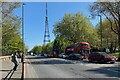
North on Crystal Palace Parade, mid-morning
Image: © Robin Stott
Taken: 30 Apr 2022
0.05 miles