IMAGES TAKEN NEAR TO
Central Hill, LONDON, SE19 1BL
Introduction
This page details the photographs taken nearby to Central Hill, SE19 1BL by members of the Geograph project.
The Geograph project started in 2005 with the aim of publishing, organising and preserving representative images for every square kilometre of Great Britain, Ireland and the Isle of Man.

There are currently over 7.5m images from over14,400 individuals and you can help contribute to the project by visiting https://www.geograph.org.uk
Image Map
Images are licensed for reuse under creativecommons.org/licenses/by-sa/2.0
Notes
- Clicking on the map will re-center to the selected point.
- The higher the marker number, the further away the image location is from the centre of the postcode.
Image Listing (362 Images Found)
Images are licensed for reuse under creativecommons.org/licenses/by-sa/2.0
Image
Details
Distance
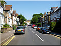
4
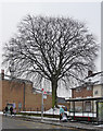
Copper beech, Central Hill
This venerable specimen probably once graced the spacious lawns of a big house, but now graces the green space outside a modern block of flats, Gatestone Court.
Image: © Stephen Richards
Taken: 5 Feb 2012
0.03 miles
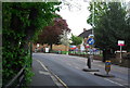
5
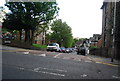
Upper Norwood: Gatestone Road
Looking north from Bedwardine Road
Image: © Dr Neil Clifton
Taken: 26 Jul 2012
0.04 miles
6
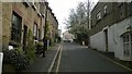
Haynes Lane, SE19
To the left lie Victorian terraced houses, to the right workshops tucked behind the loading bay of Sainsbury's.
Image: © Christopher Hilton
Taken: 21 Apr 2016
0.05 miles
7
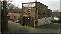
Workshops, Haynes Lane, SE19
Tucked off the Norwood triangle down Haynes Lane, an area of workshops below Sainsbury's recalls Norwood's history as a hub of light engineering; they are now used by artisans, craftsmen and women, and antique sellers.
The purpose of the tyrannosaurus, seen above the parked car, was unclear.
At the extreme right of the picture, the road turns through ninety degrees along the back of the workshops and, passing through barriers that stop vehicles, becomes Bedwardine Road.
Image: © Christopher Hilton
Taken: 21 Apr 2016
0.05 miles
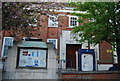
10
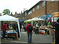
Crystal Palace Food Market
A Saturday market of various organic and artisan foods, taking place where Haynes Lane meets Bedwardine Road. The buildings on the right are part of a complex of workshops and second-hand shops that back onto the Sainsbury's development on Westow Street.
Image: © Christopher Hilton
Taken: 18 May 2013
0.05 miles