IMAGES TAKEN NEAR TO
Lower Road, LONDON, SE1 8SJ
Introduction
This page details the photographs taken nearby to Lower Road, SE1 8SJ by members of the Geograph project.
The Geograph project started in 2005 with the aim of publishing, organising and preserving representative images for every square kilometre of Great Britain, Ireland and the Isle of Man.

There are currently over 7.5m images from over14,400 individuals and you can help contribute to the project by visiting https://www.geograph.org.uk
Image Map
Images are licensed for reuse under creativecommons.org/licenses/by-sa/2.0
Notes
- Clicking on the map will re-center to the selected point.
- The higher the marker number, the further away the image location is from the centre of the postcode.
Image Listing (1630 Images Found)
Images are licensed for reuse under creativecommons.org/licenses/by-sa/2.0
Image
Details
Distance
1
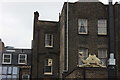
Lower Marsh camel
This is at the back of Lower Marsh, visible from the approach road to Waterloo station. Presumably at the back of the pub called the Elusive Camel.
Image: © Robert Eva
Taken: 2 Jun 2016
0.01 miles
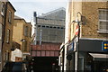
2
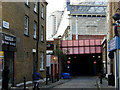
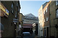
Launcelot Street, Waterloo
Launcelot Street, leading under Waterloo Station, from its junction with Lower Marsh.
Image: © Stephen McKay
Taken: 29 Oct 2007
0.02 miles
4

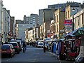
Lower Marsh, Lambeth
View down a line of market stalls after the day's business.
Image: © Des Blenkinsopp
Taken: 3 May 2011
0.02 miles
5
Lower Marsh, Waterloo
Market stalls line this narrow street which runs parallel to the side of Waterloo station.
Image: © Stephen McKay
Taken: 2 Nov 2006
0.02 miles
6
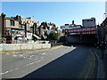
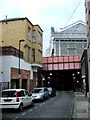
View of the former Waterloo International terminal and railway bridge on Launcelot Street
Looking north-northwest from Lower Marsh.
Image: © Robert Lamb
Taken: 13 Mar 2016
0.02 miles
9
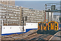
Waterloo Station during construction of International station, 1990
View northward on Platforms 19/20 to No. 21, with EMUs on Windsor Line trains: ex-LSWR Waterloo - Clapham Junction - Richmond - Staines - Windsor/Reading line. The photograph was taken at the same time as Image], during the early stages of the construction of Waterloo International on the same site. Beyond is York Road and the Shell Centre.
Image: © Ben Brooksbank
Taken: 17 Aug 1990
0.02 miles
10
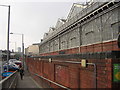
View of Waterloo Station from Lower Marsh
Looking southeast.
Image: © Robert Lamb
Taken: 14 Sep 2019
0.02 miles