IMAGES TAKEN NEAR TO
St. Margarets Terrace, LONDON, SE18 7RN
Introduction
This page details the photographs taken nearby to St. Margarets Terrace, SE18 7RN by members of the Geograph project.
The Geograph project started in 2005 with the aim of publishing, organising and preserving representative images for every square kilometre of Great Britain, Ireland and the Isle of Man.

There are currently over 7.5m images from over14,400 individuals and you can help contribute to the project by visiting https://www.geograph.org.uk
Image Map (Loading...)


Getting Data...Please wait
Leaflet Map data © OpenStreetMap
Images are licensed for reuse under creativecommons.org/licenses/by-sa/2.0
Notes
- Clicking on the map will re-center to the selected point.
- The higher the marker number, the further away the image location is from the centre of the postcode.
Image Listing (75 Images Found)
Images are licensed for reuse under creativecommons.org/licenses/by-sa/2.0
Image
Details
Distance
1
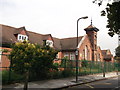
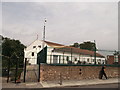
St. Margaret's Primary School, Woolwich
Church of England, on St. Margaret's Grove.
Image: © David Anstiss
Taken: 21 Aug 2011
0.04 miles
2
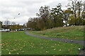
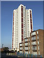
Plumstead Common
This view looks from St Margaret's Grove near St Margaret's School across a triangle of Plumstead Common towards the Victorian houses of Blendon Terrace. The tower block Everitt House is horribly out of scale with its attractive surroundings. It was built in 1976 on the site of the demolished St Margaret's Church.
Image: © Marathon
Taken: 8 Mar 2011
0.06 miles
3
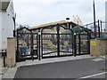
Shree Swaminarayan Temple, Plumstead Common
This Hindu Temple in St Margarets Terrace has recently been expanded and also has new entrance gates.
Image: © Marathon
Taken: 25 Dec 2018
0.08 miles
4
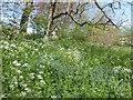
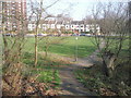
Wildflowers on Plumstead Common
This wildflower area seems to have just come up without being planted. The white of cow parsley is particularly prominent as is the blue of green alkanet. The building in the background through the gap is St Margaret's School.
Image: © Marathon
Taken: 15 Apr 2020
0.09 miles
5
SKSS Temple
Shree Kutch Satsang Swaminarayan Temple on St. Margarets Grove.
Part of the Hindu faith.
Image: © David Anstiss
Taken: 21 Aug 2011
0.09 miles
6
High rise flats, Plumstead
Low rise and high rise blocks of flats in Plumstead, South East London.
Image: © Malc McDonald
Taken: 22 Oct 2011
0.11 miles
7
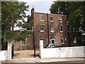
St Margaret's Old Vicarage, Plumstead Common
At 23A Vicarage Road.
The railings and gate in front of the property are Grade II listed.
See http://www.britishlistedbuildings.co.uk/en-396630-railings-and-gate-piers-to-forecourt-of- for more details.
Image: © David Anstiss
Taken: 21 Aug 2011
0.11 miles
8
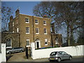
Bramblebury House, Vicarage Road, Plumstead
Bramblebury House was built in 1793, and later became the vicarage to St. Margaret’s Church which was built on Plumstead Common in 1859. The church was demolished in the 1970s and the former vicarage is now a private house.
Image: © Marathon
Taken: 8 Mar 2011
0.11 miles