IMAGES TAKEN NEAR TO
Burrage Road, LONDON, SE18 7LR
Introduction
This page details the photographs taken nearby to Burrage Road, SE18 7LR by members of the Geograph project.
The Geograph project started in 2005 with the aim of publishing, organising and preserving representative images for every square kilometre of Great Britain, Ireland and the Isle of Man.

There are currently over 7.5m images from over14,400 individuals and you can help contribute to the project by visiting https://www.geograph.org.uk
Image Map
Images are licensed for reuse under creativecommons.org/licenses/by-sa/2.0
Notes
- Clicking on the map will re-center to the selected point.
- The higher the marker number, the further away the image location is from the centre of the postcode.
Image Listing (29 Images Found)
Images are licensed for reuse under creativecommons.org/licenses/by-sa/2.0
Image
Details
Distance
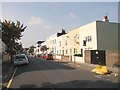
2
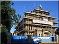
Conversion nearly complete
The former church of St James, Plumstead on Burrage Road. From 1966-2003 it was used as a theatre but has recently been converted to apartments.
Image: © Stephen Craven
Taken: 14 Jul 2005
0.04 miles
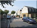
3
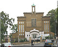
Former St James church, Plumstead
The conversion shown in Image is now complete and this former church is now apartments for sale or letting.
Image: © Stephen Craven
Taken: 21 Jul 2007
0.05 miles
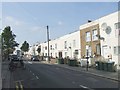
4
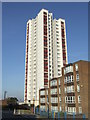
High rise flats, Plumstead
Low rise and high rise blocks of flats in Plumstead, South East London.
Image: © Malc McDonald
Taken: 22 Oct 2011
0.06 miles
8
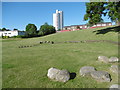
Morning sunshine on the Glyndon Estate
The hills on this area of grassland on the Glyndon Estate are almost certainly artificial. In the distance is Claymill House on Glenmount Path. The building on the left is the Glyndon Community Recreation Centre in Raglan Road. This was taken at half past seven on a fine May morning.
Image: © Marathon
Taken: 24 May 2016
0.18 miles
9
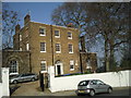
Bramblebury House, Vicarage Road, Plumstead
Bramblebury House was built in 1793, and later became the vicarage to St. Margaret’s Church which was built on Plumstead Common in 1859. The church was demolished in the 1970s and the former vicarage is now a private house.
Image: © Marathon
Taken: 8 Mar 2011
0.18 miles
10
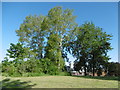
Top of the hill on the Glyndon Estate
The hills on this area of grassland on the Glyndon Estate are almost certainly artificial. This was taken at half past seven on a fine May morning at the top of the hill seen at http://www.geograph.org.uk/photo/4966643 The tall buildings in the far distance are in central Woolwich.
Image: © Marathon
Taken: 24 May 2016
0.18 miles