IMAGES TAKEN NEAR TO
Raglan Road, LONDON, SE18 7JB
Introduction
This page details the photographs taken nearby to Raglan Road, SE18 7JB by members of the Geograph project.
The Geograph project started in 2005 with the aim of publishing, organising and preserving representative images for every square kilometre of Great Britain, Ireland and the Isle of Man.

There are currently over 7.5m images from over14,400 individuals and you can help contribute to the project by visiting https://www.geograph.org.uk
Image Map
Images are licensed for reuse under creativecommons.org/licenses/by-sa/2.0
Notes
- Clicking on the map will re-center to the selected point.
- The higher the marker number, the further away the image location is from the centre of the postcode.
Image Listing (62 Images Found)
Images are licensed for reuse under creativecommons.org/licenses/by-sa/2.0
Image
Details
Distance
3
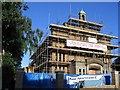
Conversion nearly complete
The former church of St James, Plumstead on Burrage Road. From 1966-2003 it was used as a theatre but has recently been converted to apartments.
Image: © Stephen Craven
Taken: 14 Jul 2005
0.13 miles
5
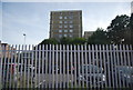
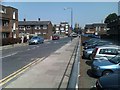
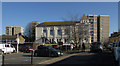
Towerblock, near Woolwich Arsenal Station
Image: © N Chadwick
Taken: 21 Aug 2013
0.14 miles
6
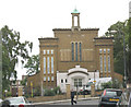
Former St James church, Plumstead
The conversion shown in Image is now complete and this former church is now apartments for sale or letting.
Image: © Stephen Craven
Taken: 21 Jul 2007
0.15 miles
7
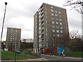
Ormsby Point, Woolwich
One of several tower blocks on the edge of Woolwich town centre, viewed from Vincent Road. The further block is Sandham Point.
Image: © Stephen Craven
Taken: 3 Dec 2011
0.15 miles
8
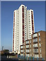
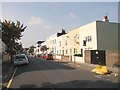
High rise flats, Plumstead
Low rise and high rise blocks of flats in Plumstead, South East London.
Image: © Malc McDonald
Taken: 22 Oct 2011
0.15 miles
9
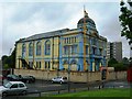
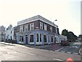
Sikh Temple, Ramgarhia Association, Masons Hill, SE18 6EJ
Image: © Danny P Robinson
Taken: 28 May 2007
0.16 miles
10
Sikh temple, Woolwich
The Ramgarhia Association Gurdwara shown in Image has lost its bright colours. "This building dates to 1889 and was originally the Freemasons hall and then the Woolwich Town & Social Club before being acquired by the Sikh Association" http://edithsstreets.blogspot.com/2015/01/railway-from-london-bridge-to-gravesend_10.html (A brilliant site by the way).
Behind the gurdwara are tower blocks on the Armstrong Estate.
Image: © Derek Harper
Taken: 24 Feb 2019
0.16 miles