IMAGES TAKEN NEAR TO
Plumstead Road, LONDON, SE18 7DD
Introduction
This page details the photographs taken nearby to Plumstead Road, SE18 7DD by members of the Geograph project.
The Geograph project started in 2005 with the aim of publishing, organising and preserving representative images for every square kilometre of Great Britain, Ireland and the Isle of Man.

There are currently over 7.5m images from over14,400 individuals and you can help contribute to the project by visiting https://www.geograph.org.uk
Image Map
Images are licensed for reuse under creativecommons.org/licenses/by-sa/2.0
Notes
- Clicking on the map will re-center to the selected point.
- The higher the marker number, the further away the image location is from the centre of the postcode.
Image Listing (53 Images Found)
Images are licensed for reuse under creativecommons.org/licenses/by-sa/2.0
Image
Details
Distance
1
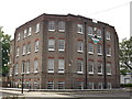
Greenwich Leisure Limited, Royal Arsenal West
Council Offices on Seymour Street.
Behind the offices (just seen on the left - yellow bricks) is the Grade II listed Royal Arsenal Middlegate House.
See http://www.britishlistedbuildings.co.uk/en-200489-royal-arsenal-middlegate-house-woolwich for more details.
Image: © David Anstiss
Taken: 21 Aug 2011
0.06 miles
2
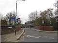
Maxey Road bridge
The bridge crosses the North Kent railway line. There seems to be confusion over the speed limit at this point, with 30mph / 20mph signs at opposite sides of the road! There are also signs for the London Cycle Network.
Image: © Stephen Craven
Taken: 3 Dec 2011
0.09 miles
3
Duke of Wellington Avenue, Royal Arsenal West
This road leads from Tom Cribb Road into the various new warehouses and office blocks of the converted Royal Arsenal and the disused and demolished army Ordnance Factories.
Image: © David Anstiss
Taken: 21 Aug 2011
0.10 miles
4
Railway between Plumstead and Woolwich
Viewed from Maxey Road bridge, this is the 14.07 Cannon Street circular service leaving Woolwich Arsenal.
Image: © Stephen Craven
Taken: 3 Dec 2011
0.11 miles
5
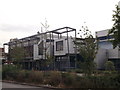
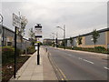
Greenwich Community College (2)
On the junction of Plumstead Road (in front) and Villas Road.
Image: © David Anstiss
Taken: 21 Aug 2011
0.11 miles
6
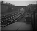
A view to Plumstead in 1959
Taken from the recently extended Up platform at Woolwich Arsenal station on a damp and dull day in 1959, looking eastwards towards Plumstead station. Sidings on both sides of the track still existed then, as did the signal box just right of centre. See Image for a rather more recent (and sunny) picture!
Taken in TQ4378, but from just beyond the signal box onwards is in TQ4478.
A closer view of the signal box can be found on Image
Scanned from a 2.25 inch square black and white negative.
Image: © John Webb
Taken: Unknown
0.12 miles
7
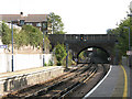
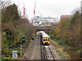
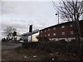
Straight from Woolwich to Belvedere
Looking east from Woolwich Arsenal station along a 5.7km stretch of dead straight railway. It runs across what was once Plumstead Marshes, before the line bends south at Belvedere towards Dartford. In this view you can just see the next station at Plumstead, 800m away.
See Image for a 1959 view of the same bridge showing several tracks that have since been removed.
Image: © Stephen Craven
Taken: 10 Oct 2009
0.12 miles
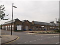
8
Greenwich Community College
On the junction of Plumstead Road and Villas Road (in front).
Image: © David Anstiss
Taken: 21 Aug 2011
0.12 miles
9
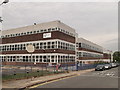
Buildings on Plumstead Road
Greenwich Community College is next to the flats on the left
Image: © David Howard
Taken: 23 Feb 2014
0.13 miles
10
Gunnery Terrace, Royal Arsenal
Former army ordnance warehouse converted into modern office and warehouse space.
On Cornwallis Road.
Image: © David Anstiss
Taken: 21 Aug 2011
0.13 miles