IMAGES TAKEN NEAR TO
Crescent Road, LONDON, SE18 7AQ
Introduction
This page details the photographs taken nearby to Crescent Road, SE18 7AQ by members of the Geograph project.
The Geograph project started in 2005 with the aim of publishing, organising and preserving representative images for every square kilometre of Great Britain, Ireland and the Isle of Man.

There are currently over 7.5m images from over14,400 individuals and you can help contribute to the project by visiting https://www.geograph.org.uk
Image Map
Images are licensed for reuse under creativecommons.org/licenses/by-sa/2.0
Notes
- Clicking on the map will re-center to the selected point.
- The higher the marker number, the further away the image location is from the centre of the postcode.
Image Listing (181 Images Found)
Images are licensed for reuse under creativecommons.org/licenses/by-sa/2.0
Image
Details
Distance
1
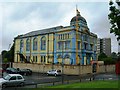
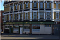
Sikh Temple, Ramgarhia Association, Masons Hill, SE18 6EJ
Image: © Danny P Robinson
Taken: 28 May 2007
0.06 miles
2
Sikh temple, Woolwich
The Ramgarhia Association Gurdwara shown in Image has lost its bright colours. "This building dates to 1889 and was originally the Freemasons hall and then the Woolwich Town & Social Club before being acquired by the Sikh Association" http://edithsstreets.blogspot.com/2015/01/railway-from-london-bridge-to-gravesend_10.html (A brilliant site by the way).
Behind the gurdwara are tower blocks on the Armstrong Estate.
Image: © Derek Harper
Taken: 24 Feb 2019
0.07 miles
3
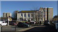
Towerblock, near Woolwich Arsenal Station
Image: © N Chadwick
Taken: 21 Aug 2013
0.08 miles
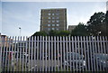
4
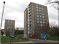
Ormsby Point, Woolwich
One of several tower blocks on the edge of Woolwich town centre, viewed from Vincent Road. The further block is Sandham Point.
Image: © Stephen Craven
Taken: 3 Dec 2011
0.09 miles
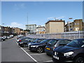
5
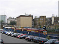
Woolwich Arsenal Station and car park (pre-DLR)
This 2005 view is already out of date because the Docklands Light Railway terminus is presently (2006) under construction at the far side of the station. The freight train is aggregate unloaded at Angerstein Wharf Image
Image: © Stephen Craven
Taken: 21 Sep 2005
0.11 miles
6
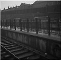
Woolwich Arsenal Station - 1959 - Cattle Pens
Cattle pens photographed on a damp day in 1959, looking from the East end of the Up platform. It may seem odd that such facilities should be in such an urban place, but at one time cattle were bought in to go to the RACS (Royal Arsenal Co-operative Society) abattoir off Garland Road, part of their Woodlands Farm. That traffic had stopped by the time of this picture.
A more recent view Image, taken in the opposite direction, shows the area now forming a car park.
Scanned from 2.25 inch square black and white negatives.
Image: © John Webb
Taken: Unknown
0.12 miles
7
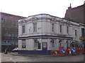
Anglesea Arms, Public House, Woolwich
Shepherd Neame Pub on the junction of Anglesea Avenue (on the left) and Anglesea Road (on the right).
Image: © David Anstiss
Taken: 15 Feb 2012
0.12 miles
8
Development overshading Anglesea Arms
In the foreground is a Shepherd Neame Pub on Anglesea Avenue.
In the background is the new large development site on Anglesea Road, this replaces a block of flats called Walpole Place.
Image: © David Anstiss
Taken: 15 Feb 2012
0.12 miles
10
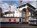
Woolwich Arsenal Station and car park (post-DLR)
As seen from the car-park beside Vincent Road.
Along the grey metal fence is a gate leading to Platform 1 and then further access around the station including the new DLR Platforms.
Compare with Image, not much change except the colour of the fence !
Image: © David Anstiss
Taken: 5 Sep 2012
0.13 miles