IMAGES TAKEN NEAR TO
Major Draper Street, LONDON, SE18 6ZF
Introduction
This page details the photographs taken nearby to Major Draper Street, SE18 6ZF by members of the Geograph project.
The Geograph project started in 2005 with the aim of publishing, organising and preserving representative images for every square kilometre of Great Britain, Ireland and the Isle of Man.

There are currently over 7.5m images from over14,400 individuals and you can help contribute to the project by visiting https://www.geograph.org.uk
Image Map (Loading...)


Getting Data...Please wait
Leaflet Map data © OpenStreetMap
Images are licensed for reuse under creativecommons.org/licenses/by-sa/2.0
Notes
- Clicking on the map will re-center to the selected point.
- The higher the marker number, the further away the image location is from the centre of the postcode.
Image Listing (358 Images Found)
Images are licensed for reuse under creativecommons.org/licenses/by-sa/2.0
Image
Details
Distance
1

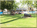
Loose Cannon
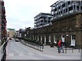
There are a lot of old guns around the Woolwich Arsenal site. A lot of advertising for Berkeley Homes too.
Massive redevelopment of the old military site into apartment blocks, very different from the older area on the other side of a busy dual carriageway.
Image: © Des Blenkinsopp
Taken: 21 Oct 2010
0.01 miles
2
Cannon barrels, Royal Arsenal site
One of several 'heritage' exhibits around the redeveloped Royal Arsenal site.
Image: © Stephen Craven
Taken: 20 Sep 2008
0.02 miles
3

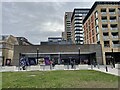
Woolwich Elizabeth Line station
The station entrance faces Dial Arch Square. The line is underground here. The station opened in May 2022. Note the grass has dried out.
Image: © Ian Taylor
Taken: 12 Aug 2022
0.03 miles
4
Woolwich railway station, London
Opened in 2022 by Crossrail Ltd. on the Elizabeth Line from Abbey Wood to Paddington. The station is part of the National Rail Network but run by Transport for London.
View east at the station building, constructed within the former royal dockyard. Ironically, Woolwich Dockyard railway station (https://www.geograph.org.uk/photo/3683469) is not in the dockyard!
Image: © Nigel Thompson
Taken: 14 Oct 2022
0.03 miles
5
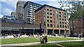
Woolwich Station on the Elizabeth Line
Overlooked by the tall buildings of the Royal Arsenal Riverside development.
Image: © David Martin
Taken: 20 Jul 2024
0.03 miles
6
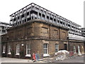
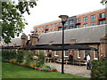
Building 10 External Wall, Royal Arsenal
Former (grade II listed) carriage works, smitheries and workshops. As seen Marlborough Road. The external wall buildings have been converted into houses.
In the background is new apartment blocks built on the former courtyard area and central workshops.
See http://www.britishlistedbuildings.co.uk/en-468763-royal-arsenal-former-paper-cartridge-fac for more details about the buildings.
Image: © David Anstiss
Taken: 21 Aug 2011
0.03 miles
8
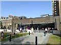
Woolwich Elizabeth Line station
The Elizabeth Line between Paddington and Abbey Wood started operating on 24th May. Woolwich Elizabeth Line station is some 100 yards north of the Southeastern and DLR stations and is in the Royal Arsenal development. The interior of the station can be seen at https://www.geograph.org.uk/photo/7185010
Image: © Marathon
Taken: 17 Jun 2022
0.04 miles
9
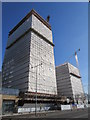
New Development Block in Royal Arsenal
These large blocks of Apartments are being constructed beside the A206 Plumstead Road.
Image: © David Anstiss
Taken: 8 Mar 2015
0.04 miles
10
The Dial Arch Public House, Royal Arsenal, Woolwich
This Grade II listed building previously acted as the gate house for the historic home of British defence and munitions production. The original Dial Square building was designed by John Vanbrugh and dates from 1720, although an excavation of the site uncovered relics from the time of Roman occupation
See http://www.britishlistedbuildings.co.uk/en-200486-royal-arsenal-dial-square-entrance-range for more details about the building.
In the background is one of new apartment buildings on the site.
Image: © David Anstiss
Taken: 21 Aug 2011
0.05 miles