IMAGES TAKEN NEAR TO
Cadogan Road, LONDON, SE18 6YU
Introduction
This page details the photographs taken nearby to Cadogan Road, SE18 6YU by members of the Geograph project.
The Geograph project started in 2005 with the aim of publishing, organising and preserving representative images for every square kilometre of Great Britain, Ireland and the Isle of Man.

There are currently over 7.5m images from over14,400 individuals and you can help contribute to the project by visiting https://www.geograph.org.uk
Image Map
Images are licensed for reuse under creativecommons.org/licenses/by-sa/2.0
Notes
- Clicking on the map will re-center to the selected point.
- The higher the marker number, the further away the image location is from the centre of the postcode.
Image Listing (276 Images Found)
Images are licensed for reuse under creativecommons.org/licenses/by-sa/2.0
Image
Details
Distance
2
Building 19, Royal Arsenal (2)
As seen from Cornwallis Road.
Former Grade II listed Carriage mounting shop within the former army Ordnance depot. Now converted into offices.
See http://www.britishlistedbuildings.co.uk/en-468765-royal-arsenal-building-19-woolwich for more details about this building.
Image: © David Anstiss
Taken: 21 Aug 2011
0.03 miles
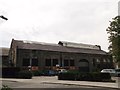
3
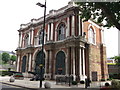
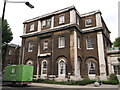
Concierge Building, Royal Arsenal
Former army ordnance office on Cadogan Road. Converted into an estate management office and residents' gymnasium (called the body Workshop).
Image: © David Anstiss
Taken: 21 Aug 2011
0.03 miles
4
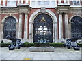
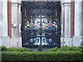
The Shell Foundry Gates, Royal Arsenal
The Royal Arsenal at Woolwich dated from the late 17th century and at the time of the First World War covered 1,285 acres and employed close to 80,000 people. It finally closed as a factory in 1967 and the Ministry of Defence moved out in 1994. Today it is open to the public and is being redeveloped for housing and community use. A full history can be seen at https://en.wikipedia.org/wiki/Royal_Arsenal
The Shell Foundry Gates were cast for the Shell Foundry at the Regents Canal Iron Works in 1856. They were removed on the closure of the Royal Ordnance Factory at Woolwich in 1966 and re-erected at the Royal Ordnance Factory at Patricroft. They were returned to the Royal Arsenal at Woolwich by the Royal Ordnance and recommissioned on 31st May 1991. They now stand on the edge of Wellington Park.
The gun on the left is a 24 pounder manufactured at the Carron Company in Falkirk, Scotland. It is said to have been employed at the Siege of St Sebastian in 1812. There is a large dent in it where it was hit by a cannon ball which killed the gun layer. A close up of the gates can be seen at https://www.geograph.org.uk/photo/5694836
Image: © Marathon
Taken: 12 Feb 2018
0.03 miles
5
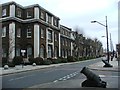
My HQ, Royal Arsenal
Former army ordnance offices (part of Building 22), on the junction of Cornwallis Road (on the left) and Cadogan Road (on the right), converted into modern apartments and flats.
Image: © David Anstiss
Taken: 21 Aug 2011
0.04 miles
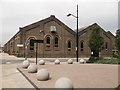
6
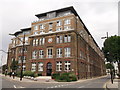
Part of Building 37, Royal Arsenal
Part of the (Grade II listed) Grand Store, E Range (building 49) of the converted former Army ordnance buildings on Cadogan Road.
Now converted into apartments. Linked to Building 36 via an ornate gateway (on the right).
See http://www.britishlistedbuildings.co.uk/en-200493-royal-arsenal-the-grand-store-e-range-bu for more details about the building.
Image: © David Anstiss
Taken: 21 Aug 2011
0.04 miles
8
The Shell Foundry Gates, Royal Arsenal
The Royal Arsenal at Woolwich dated from the late 17th century and at the time of the First World War covered 1,285 acres and employed close to 80,000 people. It finally closed as a factory in 1967 and the Ministry of Defence moved out in 1994. Today it is open to the public and is being redeveloped for housing and community use. A full history can be seen at https://en.wikipedia.org/wiki/Royal_Arsenal
The Shell Foundry Gates were cast for the Shell Foundry at the Regents Canal Iron Works in 1856. They were removed on the closure of the Royal Ordnance Factory at Woolwich in 1966 and re-erected at the Royal Ordnance Factory at Patricroft. They were returned to the Royal Arsenal at Woolwich by the Royal Ordnance and recommissioned on 31st May 1991. They now stand on the edge of Wellington Park.
Image: © Marathon
Taken: 12 Feb 2018
0.04 miles
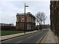
9
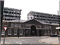
Building 10 Clocktower, Royal Arsenal
Former (grade II listed) entrance to the army Carriage works, smitheries and workshops. As seen from Cornwallis Road, opposite Cadogan Road.
In the background is new apartment blocks built on the former courtyard area and workshops.
See http://www.britishlistedbuildings.co.uk/en-200492-royal-arsenal-former-new-carriage-store- for more details about the buildings.
Image: © David Anstiss
Taken: 21 Aug 2011
0.04 miles
10
Building 19, Royal Arsenal
As seen from Cadogan Road.
Former grade II listed Carriage mounting shop within the former army Ordnance depot. Now converted into offices.
See http://www.britishlistedbuildings.co.uk/en-468765-royal-arsenal-building-19-woolwich for more details about this building.
Image: © David Anstiss
Taken: 21 Aug 2011
0.04 miles