IMAGES TAKEN NEAR TO
Brumwell Avenue, LONDON, SE18 6UX
Introduction
This page details the photographs taken nearby to Brumwell Avenue, SE18 6UX by members of the Geograph project.
The Geograph project started in 2005 with the aim of publishing, organising and preserving representative images for every square kilometre of Great Britain, Ireland and the Isle of Man.

There are currently over 7.5m images from over14,400 individuals and you can help contribute to the project by visiting https://www.geograph.org.uk
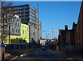
Image Map
Images are licensed for reuse under creativecommons.org/licenses/by-sa/2.0
Notes
- Clicking on the map will re-center to the selected point.
- The higher the marker number, the further away the image location is from the centre of the postcode.
Image Listing (181 Images Found)
Images are licensed for reuse under creativecommons.org/licenses/by-sa/2.0
Image
Details
Distance
2
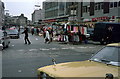
Woolwich market
Taken around 1974 from just outside the Woolwich Arsenal gates, the old tram tracks are still visible in the cobble stones running left to right between the two cars and just in front of the skirt stands. A second line crosses the foreground going 'through' the Cortina wing mirror with the other rail passing just in front of the litter.
Image: © rafflesbear
Taken: Unknown
0.02 miles
3
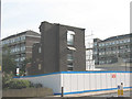
Demolition of Central Court, Woolwich
Image: © Stephen Craven
Taken: 20 Sep 2008
0.02 miles
4
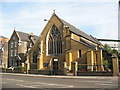
St Peter's church, Woolwich
A Catholic church near the town centre.
Image: © Stephen Craven
Taken: 20 Sep 2008
0.03 miles
5
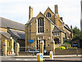
St Peter's Centre, Woolwich
The hall adjacent to the church of the same name.
Image: © Stephen Craven
Taken: 20 Sep 2008
0.04 miles
6
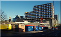
New Tesco development, Woolwich
These flats were built as part of a massive Tesco development in the centre of Woolwich which opened in November 2012. Seen here across Woolwich New Road, they totally dominate the largely Victorian scale town centre. I personally think they are hideous.
Image: © Marathon
Taken: 11 Jan 2014
0.05 miles
7
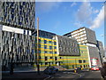
Woolwich, SE18
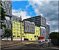
Work continues apace on the 1.4 million sq.ft "Woolwich Central" development expected to deliver 960 homes with up-to-three bedrooms, a supermarket, shops and other services for the town. The scheme, seen here on the side of Grand Depot Road and looking towards Woolwich New Road, is being delivered by mixed-used developer Spenhill, the regeneration subsidiary of Tesco plc. The tower of Woolwich Town Hall is also visible.
Image: © David Hallam-Jones
Taken: 1 Jan 2013
0.05 miles
8
Woolwich, SE18
The 1.4 million sq.ft Woolwich Central development in this picture is being delivered by 'mixed-used developer' Spenhill, the regeneration subsidiary of Tesco plc. It is expected to deliver 960 homes with up-to-three bedrooms, a supermarket, shops and other services for the town. Here the scheme is seen on the side of Grand Depot Road from Woolwich New Road, with Sandy Hill Lane to the photographer's immediate right.
Image: © David Hallam-Jones
Taken: 1 Jan 2013
0.06 miles
9
Woolwich: Woolwich Central
Winner of the Britain's Worst Building Carbuncle Cup of 2014. https://www.building.co.uk/news/this-years-carbuncle/5070691.article. Architects: Sheppard Robson.
Image: © Jim Osley
Taken: 3 Jul 2019
0.06 miles