IMAGES TAKEN NEAR TO
Hopton Road, LONDON, SE18 6TG
Introduction
This page details the photographs taken nearby to Hopton Road, SE18 6TG by members of the Geograph project.
The Geograph project started in 2005 with the aim of publishing, organising and preserving representative images for every square kilometre of Great Britain, Ireland and the Isle of Man.

There are currently over 7.5m images from over14,400 individuals and you can help contribute to the project by visiting https://www.geograph.org.uk
Image Map
Images are licensed for reuse under creativecommons.org/licenses/by-sa/2.0
Notes
- Clicking on the map will re-center to the selected point.
- The higher the marker number, the further away the image location is from the centre of the postcode.
Image Listing (239 Images Found)
Images are licensed for reuse under creativecommons.org/licenses/by-sa/2.0
Image
Details
Distance
1
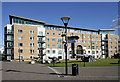
The Guns of Number One Street
Recent development on the Woolwich Arsenal site, with some hardware left by the previous tenants.
Don't mess with the neighbourhood watch round here....
Image: © Des Blenkinsopp
Taken: 21 Oct 2010
0.01 miles
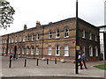
3
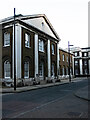
Woolwich Arsenal : Grand Stores building, Hopton Road
Image: © Jim Osley
Taken: 2 Feb 2024
0.02 miles
5
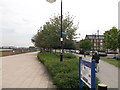
Thames Path at Royal Arsenal Woolwich
The long distance path leads beside an esplanade beside the River Thames heading towards Iron Pier.
The Thames Cycle Route (slightly diverges away) heading through a planted section of the converted Ordnance Factories (now apartments).
Image: © David Anstiss
Taken: 21 Aug 2011
0.04 miles
6
Building 45, Royal Arsenal
Former army ordnance offices, converted into modern apartments and flats.
Image: © David Anstiss
Taken: 21 Aug 2011
0.04 miles
7
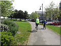
Thames cycle path alongside Marlborough Road
At this point the Thames Path has separate strands for walkers (on the river wall) and cyclists (about 20 metres further inland).
Image: © Stephen Craven
Taken: 21 Apr 2014
0.04 miles
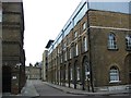
8
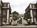
Gateway between Building 37 and Building 36, Royal Arsenal
Part of the (Grade II listed) Grand Store, E Range of the converted former Army ordnance buildings on Cadogan Road.
Now converted into apartments.
See http://www.britishlistedbuildings.co.uk/en-200493-royal-arsenal-the-grand-store-e-range-bu for more details about the building.
Image: © David Anstiss
Taken: 21 Aug 2011
0.05 miles
9
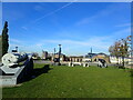
James Clavell Square at the Royal Arsenal
The Royal Arsenal at Woolwich dated from the late 17th century and at the time of the First World War covered 1,285 acres and employed close to 80,000 people. It finally closed as a factory in 1967 and the Ministry of Defence moved out in 1994. Today it is open to the public and is being redeveloped for housing and community use. A full history can be seen at https://en.wikipedia.org/wiki/Royal_Arsenal
This cannon is one of a number of guns on James Clavell Square. In the background can be seen the Antony Gormley statues next to the Royal Arsenal Pier - see https://www.geograph.org.uk/photo/7011886
Image: © Marathon
Taken: 5 Nov 2021
0.05 miles
10
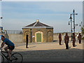
Riverside guardroom (2 of 2)
Details of the building can be found with the photo of its pair at Image The black figures comprise the art installation 'Assembly' by Peter Burke (2005).
Image: © Stephen Craven
Taken: 20 Sep 2008
0.05 miles