IMAGES TAKEN NEAR TO
Skeffington Street, LONDON, SE18 6SR
Introduction
This page details the photographs taken nearby to Skeffington Street, SE18 6SR by members of the Geograph project.
The Geograph project started in 2005 with the aim of publishing, organising and preserving representative images for every square kilometre of Great Britain, Ireland and the Isle of Man.

There are currently over 7.5m images from over14,400 individuals and you can help contribute to the project by visiting https://www.geograph.org.uk
Image Map
Images are licensed for reuse under creativecommons.org/licenses/by-sa/2.0
Notes
- Clicking on the map will re-center to the selected point.
- The higher the marker number, the further away the image location is from the centre of the postcode.
Image Listing (96 Images Found)
Images are licensed for reuse under creativecommons.org/licenses/by-sa/2.0
Image
Details
Distance
1
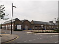
Gunnery Terrace, Royal Arsenal
Former army ordnance warehouse converted into modern office and warehouse space.
On Cornwallis Road.
Image: © David Anstiss
Taken: 21 Aug 2011
0.06 miles
2
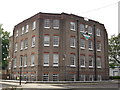
Greenwich Leisure Limited, Royal Arsenal West
Council Offices on Seymour Street.
Behind the offices (just seen on the left - yellow bricks) is the Grade II listed Royal Arsenal Middlegate House.
See http://www.britishlistedbuildings.co.uk/en-200489-royal-arsenal-middlegate-house-woolwich for more details.
Image: © David Anstiss
Taken: 21 Aug 2011
0.08 miles
3
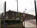
Gunnery House, Royal Arsenal
Former army ordnance warehouse converted into modern office and warehouse space.
On Arsenal Way.
Image: © David Anstiss
Taken: 21 Aug 2011
0.09 miles
4
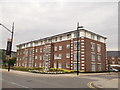
Housing block on Hastings Street, Royal
Large block of houses on Duke of Wellington Avenue.
Part of the Berkeley Homes conversion of the former army warehouses and factories.
Image: © David Anstiss
Taken: 21 Aug 2011
0.09 miles
5
Duke of Wellington Avenue, Royal Arsenal West
This road leads from Tom Cribb Road into the various new warehouses and office blocks of the converted Royal Arsenal and the disused and demolished army Ordnance Factories.
Image: © David Anstiss
Taken: 21 Aug 2011
0.09 miles
6
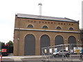
The Energy Centre, Royal Arsenal
Former power plant on Arsenal Way, to the disused army ordnance factories, now powers the converted offices and apartments.
Image: © David Anstiss
Taken: 21 Aug 2011
0.10 miles
7
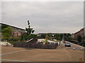
Duke of Wellington Park, Royal Arsenal
This square recreational ground is within the converted army ordnance warehouses and offices. Set between Hastings Street and Cadogan Road.
Image: © David Anstiss
Taken: 21 Aug 2011
0.11 miles
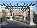
8
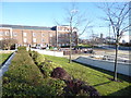
In the Royal Arsenal
The Royal Arsenal at Woolwich dated from the late 17th century and at the time of the First World War covered 1,285 acres and employed close to 80,000 people. It finally closed as a factory in 1967 and the Ministry of Defence moved out in 1994. Today it is open to the public and is being redeveloped for housing and community use. A full history can be seen at https://en.wikipedia.org/wiki/Royal_Arsenal
This is looking across Wellington Park.
Image: © Marathon
Taken: 12 Feb 2018
0.12 miles
9
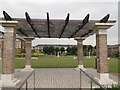
Pergola in Duke of Wellington Park, Royal Arsenal
This square recreational ground is within the converted army ordnance warehouses and offices. Set between Hastings Street and Cadogan Road.
In the park is a grade II listed statue of the Duke of Wellington.
Image: © David Anstiss
Taken: 21 Aug 2011
0.12 miles
10
Wellington Park, Royal Arsenal
The Royal Arsenal at Woolwich dated from the late 17th century and at the time of the First World War covered 1,285 acres and employed close to 80,000 people. It finally closed as a factory in 1967 and the Ministry of Defence moved out in 1994. Today it is open to the public and is being redeveloped for housing and community use. A full history can be seen at https://en.wikipedia.org/wiki/Royal_Arsenal
This is looking across Wellington Park.
Image: © Marathon
Taken: 12 Feb 2018
0.13 miles