IMAGES TAKEN NEAR TO
John Wilson Street, LONDON, SE18 6PZ
Introduction
This page details the photographs taken nearby to John Wilson Street, SE18 6PZ by members of the Geograph project.
The Geograph project started in 2005 with the aim of publishing, organising and preserving representative images for every square kilometre of Great Britain, Ireland and the Isle of Man.

There are currently over 7.5m images from over14,400 individuals and you can help contribute to the project by visiting https://www.geograph.org.uk
Image Map
Images are licensed for reuse under creativecommons.org/licenses/by-sa/2.0
Notes
- Clicking on the map will re-center to the selected point.
- The higher the marker number, the further away the image location is from the centre of the postcode.
Image Listing (183 Images Found)
Images are licensed for reuse under creativecommons.org/licenses/by-sa/2.0
Image
Details
Distance
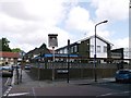
1
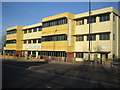
Woolwich: Ferryview Health Centre
This modular building is on the A205 John Wilson Street, and accommodates a seven-GP practice, along with community health services staff and a mental health team.
The Centre was designed and built by Yorkon Limited using an innovative modular building method. Sixty-six steel framed modules were manufactured in York, delivered by road and craned into position in just a few days, so minimising local disruption and reducing the time on site from 15 months to around 9 months. Yorkon's website is here http://www.yorkon.co.uk/
Image: © Nigel Cox
Taken: 31 Jan 2007
0.03 miles
3
"Each for all and all for each" - the Cooperative building, Woolwich
Slogan above the main entrance.
Image: © John Lord
Taken: 21 Jan 2013
0.05 miles
5
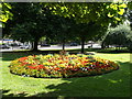
Flower display St Mary's Gardens, Woolwich
Colourful flower display in the churchyard gardens beside John Wilson Street.
Image: © David Anstiss
Taken: 26 Aug 2012
0.05 miles
6
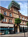
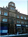
147 Powis Street
Former Head Office of the Royal Arsenal Co-operative Society Ltd. Built 1903 and modernised in the 1970's when the terracota was cleaned of years on London grime this building is in the possession of the local council and is slowly degrading
Image: © John Finch
Taken: 15 Jul 2011
0.06 miles
7
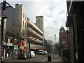
Flats on Powis Street, Woolwich
The former Royal Arsenal Cooperative Society's 1930s store being converted.
Image: © Christopher Hilton
Taken: 20 Jan 2016
0.06 miles
8
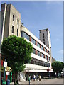
Disused department store, Woolwich
The 1930s built RACS (Royal Arsenal Co-operative Society) disused department store in Woolwich, in South East London. Built as a replacement for the earlier 1900s store on the opposite side of Powis Street. The largest department store in Woolwich, the top floor had a restaurant in one half and the electrical department in the other.
Image: © Malc McDonald
Taken: 3 Sep 2011
0.06 miles
9
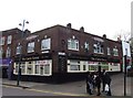
King George V, Public House, Woolwich
On the junction of Rectory Place and Kingman Street (on the right).
Image: © David Anstiss
Taken: 26 Aug 2012
0.07 miles
10
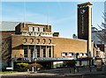
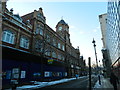
Woolwich : Christ Faith Tabernacle
Grade II Former Granada cinema, built 1936-7 for Granada Theatres. Architects: Cecil Masey (1881- 1960) and Reginald Harold Uren (1903-88) with interior design by Theodore Komisarjevsky (1882-1954). " - https://historicengland.org.uk/listing/the-list/list-entry/1212651
Image: © Jim Osley
Taken: 30 Jan 2020
0.07 miles