IMAGES TAKEN NEAR TO
Hare Street, LONDON, SE18 6NB
Introduction
This page details the photographs taken nearby to Hare Street, SE18 6NB by members of the Geograph project.
The Geograph project started in 2005 with the aim of publishing, organising and preserving representative images for every square kilometre of Great Britain, Ireland and the Isle of Man.

There are currently over 7.5m images from over14,400 individuals and you can help contribute to the project by visiting https://www.geograph.org.uk
Image Map
Images are licensed for reuse under creativecommons.org/licenses/by-sa/2.0
Notes
- Clicking on the map will re-center to the selected point.
- The higher the marker number, the further away the image location is from the centre of the postcode.
Image Listing (357 Images Found)
Images are licensed for reuse under creativecommons.org/licenses/by-sa/2.0
Image
Details
Distance
1
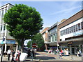
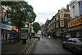
Hare Street, Woolwich
Hare Street in the Woolwich town centre.
Image: © Malc McDonald
Taken: 3 Sep 2011
0.03 miles
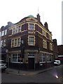
2
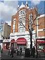
The former Shakespeare Hotel, Woolwich, London
This building at the end of Powis Street, used to be the venue for the famous "Hot Club of London". In the nineteen fifties and early sixties it was a jazz club run by the pioneer of the British traditional jazz scene George Webb. Many of the great bands of the period played there. To the great enjoyment of the contributor.
Image: © Derek Voller
Taken: 14 Mar 2013
0.03 miles
3
Beresford Street, SE18
This is the A206, a main road linking Bermondsey, Woolwich, Plumstead and beyond. These buildings back onto Rope Yard Rails Image, and it looks as though there is some redevelopment planned here. I was standing near MacBean Street.
Image: © Danny P Robinson
Taken: 28 May 2007
0.05 miles
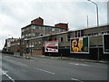
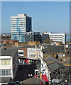
6
Disused department store, Woolwich
The 1930s built RACS (Royal Arsenal Co-operative Society) disused department store in Woolwich, in South East London. Built as a replacement for the earlier 1900s store on the opposite side of Powis Street. The largest department store in Woolwich, the top floor had a restaurant in one half and the electrical department in the other.
Image: © Malc McDonald
Taken: 3 Sep 2011
0.07 miles
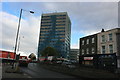
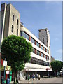
7
Riverside House, Woolwich High Street
The tallest building, looking as if it has been assailed by an ambitious graffiti artist. Built 1962-63 by A. Swift & Partners.
Now seemingly occupied by a variety of central and local government agencies.
The brief road to the fore is Barnard Close, and facing is Powis Street at its junction with Hare Street.
Image: © Stephen Richards
Taken: 1 Apr 2012
0.07 miles
10
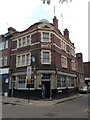
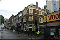
Rose's Pub Mortgramit Square Woolwich SE18
An old fashioned pub on a Wednesday lunchtime. My late great-uncle, Ernie Hawkins, lived nearby and was famous in our family for having been knocked down by a tram in the second world war blackout whilst the worse for drink. I can imagine him still in the backstreets of Woolwich.
Image: © John Kingdon
Taken: 1 Jun 2022
0.07 miles