IMAGES TAKEN NEAR TO
Barnard Close, LONDON, SE18 6JQ
Introduction
This page details the photographs taken nearby to Barnard Close, SE18 6JQ by members of the Geograph project.
The Geograph project started in 2005 with the aim of publishing, organising and preserving representative images for every square kilometre of Great Britain, Ireland and the Isle of Man.

There are currently over 7.5m images from over14,400 individuals and you can help contribute to the project by visiting https://www.geograph.org.uk
Image Map (Loading...)


Getting Data...Please wait
Leaflet Map data © OpenStreetMap
Images are licensed for reuse under creativecommons.org/licenses/by-sa/2.0
Notes
- Clicking on the map will re-center to the selected point.
- The higher the marker number, the further away the image location is from the centre of the postcode.
Image Listing (340 Images Found)
Images are licensed for reuse under creativecommons.org/licenses/by-sa/2.0
Image
Details
Distance
1
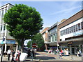
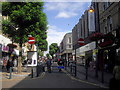
Hare Street, Woolwich
Hare Street in the Woolwich town centre.
Image: © Malc McDonald
Taken: 3 Sep 2011
0.03 miles
2
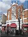
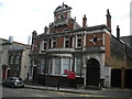
The former Shakespeare Hotel, Woolwich, London
This building at the end of Powis Street, used to be the venue for the famous "Hot Club of London". In the nineteen fifties and early sixties it was a jazz club run by the pioneer of the British traditional jazz scene George Webb. Many of the great bands of the period played there. To the great enjoyment of the contributor.
Image: © Derek Voller
Taken: 14 Mar 2013
0.03 miles
3
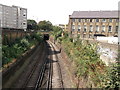
Railway to Woolwich Dockyard
As seen from a footbridge near Clare Place.
This line leads from Dartford (via Abbey Wood and Woolwich Arsenal) and heads towards Woolwich Dockyard and onwards to central London.
Image: © David Anstiss
Taken: 21 Aug 2011
0.04 miles
4
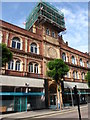
147 Powis Street
Former Head Office of the Royal Arsenal Co-operative Society Ltd. Built 1903 and modernised in the 1970's when the terracota was cleaned of years on London grime this building is in the possession of the local council and is slowly degrading
Image: © John Finch
Taken: 15 Jul 2011
0.06 miles
5
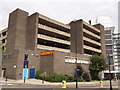
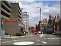
Woolwich Sainsbury's Supermarket
On the junction of Monk Street (on the left) and Calderwood Street (on the right).
Has a multi-storey car park above.
Image: © David Anstiss
Taken: 21 Aug 2011
0.07 miles
6
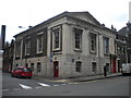
Old town hall, Woolwich
Now in use as a Citizens' Advice Bureau.
Image: © Richard Vince
Taken: 14 May 2016
0.07 miles
8
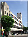
Disused department store, Woolwich
The 1930s built RACS (Royal Arsenal Co-operative Society) disused department store in Woolwich, in South East London. Built as a replacement for the earlier 1900s store on the opposite side of Powis Street. The largest department store in Woolwich, the top floor had a restaurant in one half and the electrical department in the other.
Image: © Malc McDonald
Taken: 3 Sep 2011
0.08 miles
9
Old library, Calderwood Street, Woolwich
Image: © Richard Vince
Taken: 14 May 2016
0.08 miles
10
Calderwood Street, Woolwich
Seen from Monk Street.
Image: © Richard Vince
Taken: 14 May 2016
0.08 miles