IMAGES TAKEN NEAR TO
Woolwich High Street, LONDON, SE18 6DH
Introduction
This page details the photographs taken nearby to Woolwich High Street, SE18 6DH by members of the Geograph project.
The Geograph project started in 2005 with the aim of publishing, organising and preserving representative images for every square kilometre of Great Britain, Ireland and the Isle of Man.

There are currently over 7.5m images from over14,400 individuals and you can help contribute to the project by visiting https://www.geograph.org.uk
Image Map
Images are licensed for reuse under creativecommons.org/licenses/by-sa/2.0
Notes
- Clicking on the map will re-center to the selected point.
- The higher the marker number, the further away the image location is from the centre of the postcode.
Image Listing (345 Images Found)
Images are licensed for reuse under creativecommons.org/licenses/by-sa/2.0
Image
Details
Distance
1
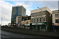
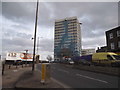
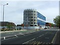
Riverside House, Woolwich High Street
The tallest building, looking as if it has been assailed by an ambitious graffiti artist. Built 1962-63 by A. Swift & Partners.
Now seemingly occupied by a variety of central and local government agencies.
The brief road to the fore is Barnard Close, and facing is Powis Street at its junction with Hare Street.
Image: © Stephen Richards
Taken: 1 Apr 2012
0.01 miles
2
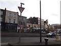
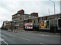
Rope Yard Rails, SE18
At the junction of Warren Lane. It looks as though there is some redevelopment planned here. The buildings on the right back onto Beresford Street. Image
Image: © Danny P Robinson
Taken: 28 May 2007
0.02 miles
3
Riverside House, Woolwich
It looks like the graffiti artists have been busy, but it's actually the design of the tiles.
Image: © David Howard
Taken: 23 Feb 2014
0.02 miles
4
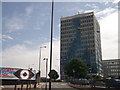
Riverside House, Woolwich
Large office block of Greenwich Borough Council on the A206 Woolwich High Street.
Image: © David Anstiss
Taken: 21 Aug 2011
0.02 miles
5
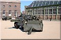
Woolwich Arsenal Laboratory Square
On the right behind the field gun is the old Chemical laboratory used for the production of 'secret' powders for use in warfare. Today it houses the larger exhibits for the Firepower collection such as the field gun and limber in the foreground.
Image: © Ken Brown
Taken: 30 Aug 2003
0.05 miles
6
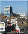
Towerblocks on Woolwich High Street viewed from the Royal Arsenal development
Looking north-northwest.
Image: © Robert Lamb
Taken: 23 Oct 2011
0.05 miles
8
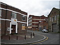
Beresford Street, SE18
This is the A206, a main road linking Bermondsey, Woolwich, Plumstead and beyond. These buildings back onto Rope Yard Rails Image, and it looks as though there is some redevelopment planned here. I was standing near MacBean Street.
Image: © Danny P Robinson
Taken: 28 May 2007
0.06 miles