IMAGES TAKEN NEAR TO
Duke Of Wellington Avenue, LONDON, SE18 6BY
Introduction
This page details the photographs taken nearby to Duke Of Wellington Avenue, SE18 6BY by members of the Geograph project.
The Geograph project started in 2005 with the aim of publishing, organising and preserving representative images for every square kilometre of Great Britain, Ireland and the Isle of Man.

There are currently over 7.5m images from over14,400 individuals and you can help contribute to the project by visiting https://www.geograph.org.uk
Image Map
Images are licensed for reuse under creativecommons.org/licenses/by-sa/2.0
Notes
- Clicking on the map will re-center to the selected point.
- The higher the marker number, the further away the image location is from the centre of the postcode.
Image Listing (365 Images Found)
Images are licensed for reuse under creativecommons.org/licenses/by-sa/2.0
Image
Details
Distance
2
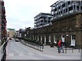
Number One Street, Woolwich
Number One Street is the main avenue of the old Royal Arsenal site. Some of the buildings have been retained for civic use and others converted to housing. The modern sculpture in the foreground was installed in 2005.
Image: © Stephen Craven
Taken: 8 Jul 2006
0.03 miles
3
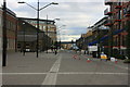
Woolwich: Duke of Wellington Avenue
Duke of Wellington Avenue is one of the main east-west thoroughfares on the former Royal Arsenal site, which is currently being refurbished as a residential development. The Royal Arsenal Property's website is here http://www.royalarsenalproperty.com/home.htm
The 1870 Ordnance Survey map shows the whole Royal Arsenal site as a blank area devoid of any detail, reflecting the secret nature of the munitions fabrication work going on at the time.
Image: © Nigel Cox
Taken: 31 Jan 2007
0.03 miles
4
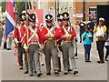
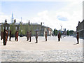
By the Left, Slow March!
Historical military display at Woolwich during the Tall Ships Race 2014.
Image: © Colin Smith
Taken: 7 Sep 2014
0.03 miles
5
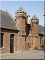
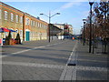
Dial Square, Royal Arsenal Woolwich
Built between 1717 and 1720; sundial added forty years later. This is the entrance to the former gun factory and smithy. World-renowned Arsenal Football Club was originally named Dial Square when founded in 1886.
Image: © Chris Martyn
Taken: 30 Jun 2006
0.03 miles
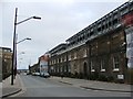
7
Building 10 External Wall, Royal Arsenal
Former (grade II listed) carriage works, smitheries and workshops. As seen Marlborough Road. The external wall buildings have been converted into houses.
In the background is new apartment blocks built on the former courtyard area and central workshops.
See http://www.britishlistedbuildings.co.uk/en-468763-royal-arsenal-former-paper-cartridge-fac for more details about the buildings.
Image: © David Anstiss
Taken: 21 Aug 2011
0.04 miles
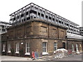
8
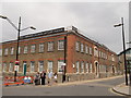
Firepower, the Royal Artillery Museum, Royal Arsenal
The museum of the Royal Artillery regiment is situated in one of the converted industrial buildings (Building 17, a former paper cartridge factory ), on the junction of Marlborough Road (on the left) and Hardinge Street (on the right).
See http://www.britishlistedbuildings.co.uk/en-468763-royal-arsenal-former-paper-cartridge-fac for more details about the building.
Image: © David Anstiss
Taken: 21 Aug 2011
0.04 miles
9
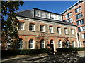
Laboratory Pavilion East at Royal Arsenal
The Royal Arsenal at Woolwich dated from the late 17th century and at the time of the First World War covered 1,285 acres and employed close to 80,000 people. It finally closed as a factory in 1967 and the Ministry of Defence moved out in 1994. Today it is open to the public and is being redeveloped for housing and community use. It comprises one of the biggest concentrations of Grade I and Grade II listed buildings converted for residential use, with more than 3,000 residents. A full history can be seen at https://en.wikipedia.org/wiki/Royal_Arsenal
This is Laboratory Pavilion East which dates from around 1696. It is Grade II Listed.
Image: © Marathon
Taken: 5 Nov 2021
0.04 miles