IMAGES TAKEN NEAR TO
Rolfe Terrace, LONDON, SE18 6BS
Introduction
This page details the photographs taken nearby to Rolfe Terrace, SE18 6BS by members of the Geograph project.
The Geograph project started in 2005 with the aim of publishing, organising and preserving representative images for every square kilometre of Great Britain, Ireland and the Isle of Man.

There are currently over 7.5m images from over14,400 individuals and you can help contribute to the project by visiting https://www.geograph.org.uk
Image Map
Images are licensed for reuse under creativecommons.org/licenses/by-sa/2.0
Notes
- Clicking on the map will re-center to the selected point.
- The higher the marker number, the further away the image location is from the centre of the postcode.
Image Listing (94 Images Found)
Images are licensed for reuse under creativecommons.org/licenses/by-sa/2.0
Image
Details
Distance
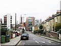
2
Brookhill Road, Woolwich
A Minimart occupies a wedge-shaped position at the junction of Sandy Hill Road (left) and Brookhill Road.
Image: © Derek Harper
Taken: 19 May 2006
0.07 miles
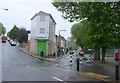
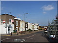
3
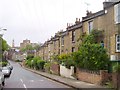
Sandy Hill Road, Woolwich
A terrace steps down a hill towards the centre of Woolwich, with the town hall prominent ahead.
Image: © Derek Harper
Taken: 19 May 2006
0.08 miles
7
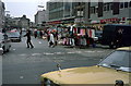
Woolwich market
Taken around 1974 from just outside the Woolwich Arsenal gates, the old tram tracks are still visible in the cobble stones running left to right between the two cars and just in front of the skirt stands. A second line crosses the foreground going 'through' the Cortina wing mirror with the other rail passing just in front of the litter.
Image: © rafflesbear
Taken: Unknown
0.10 miles
8
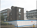
Demolition of Central Court, Woolwich
Image: © Stephen Craven
Taken: 20 Sep 2008
0.12 miles
9
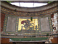
Victoria Cross memorial in St George's chapel, Woolwich
The memorial takes the form of a mosaic forming the backdrop or reredos to the altar of the former military chapel. It commemorates the many holders of the VC in the "Royal and Late Indian Artillery" from 1854 onwards - including two in the 21st century so far, 2000 and 2005.
The chapel is not normally open but was on this occasion, for Open House Weekend. For context see Image
Image: © Stephen Craven
Taken: 20 Sep 2014
0.13 miles
10
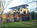
Royal Garrison Church of St George, Woolwich
St George's Garrison Church in Woolwich was built in the 1860s to serve the Royal Artillery Barracks. It was destroyed by a flying bomb on 13th July 1944. The consecrated ground was presented as a memorial garden and contains the V. C. Memorial of the Royal Regiment of Artillery. At the time this photograph was taken it was closed while repairs funded by the Heritage Lottery Fund to the tune of £396,000 were taking place. See https://www.stgeorgeswoolwich.org/ and http://www.bbc.co.uk/news/uk-england-london-15437355
Image: © Marathon
Taken: 11 Jan 2014
0.13 miles