IMAGES TAKEN NEAR TO
Aldington Road, LONDON, SE18 5TS
Introduction
This page details the photographs taken nearby to Aldington Road, SE18 5TS by members of the Geograph project.
The Geograph project started in 2005 with the aim of publishing, organising and preserving representative images for every square kilometre of Great Britain, Ireland and the Isle of Man.

There are currently over 7.5m images from over14,400 individuals and you can help contribute to the project by visiting https://www.geograph.org.uk
Image Map
Images are licensed for reuse under creativecommons.org/licenses/by-sa/2.0
Notes
- Clicking on the map will re-center to the selected point.
- The higher the marker number, the further away the image location is from the centre of the postcode.
Image Listing (346 Images Found)
Images are licensed for reuse under creativecommons.org/licenses/by-sa/2.0
Image
Details
Distance
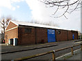
1
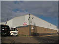
Brentons new bus garage
Brentons of Blackheath used to be based in Denham Street, East Greenwich Image but moved c.2011 to this industrial unit on the Westminster Estate.
Image: © Stephen Craven
Taken: 17 Feb 2013
0.03 miles
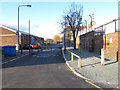
2
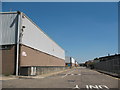
Westfield Street
The core road of the Westminster Industrial Estate, photographed from the barrier at the West end that is normally closed to prevent through traffic. See Image for a view from the other end.
Image: © Stephen Craven
Taken: 5 Aug 2007
0.03 miles
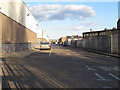
3
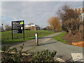
Welcome to the Thames Barrier
A fairly new "welcome" sign on the pedestrian route to the visitor centre.
Image: © Stephen Craven
Taken: 17 Feb 2013
0.03 miles
4
Hardens Manorway
Many of the roads and paths running down to the Thames are called Manorways (presumably for some historic reason that I have not yet discovered). This one is now a short dead-end off Eastmoor Street for traffic, the rest of it being a cycle path (part of NCN1 / Thames Path). The stretch of surfaced path on the right, signed as shared-use, is quite new: previously cyclists had to get round the traffic barrier in the foreground when the motor workshop beyond it was closed.
Image: © Stephen Craven
Taken: 19 Feb 2012
0.04 miles
5
Autotrans, Eastmoor Street
One of several vehicle repair businesses in this area. Autotrans repair automatic gearboxes.
Image: © Stephen Craven
Taken: 17 Feb 2013
0.04 miles
6
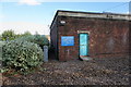
Missing sculpture?
The sign says that the sculpture is under recorded video surveillance to prevent damage. What sculpture? Did the video record its disappearance?
Image: © Bill Boaden
Taken: 11 Oct 2014
0.04 miles
7
Westfield Street
This is the spine road of the Westminster Industrial Estate in Charlton. The road is private, being accessed from the east end (this photo was taken through the normally closed gates at the west end).
Image: © Stephen Craven
Taken: 19 Feb 2012
0.04 miles
8
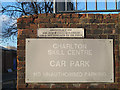
Sign for Westfield Street
The upper sign declares Westfield Street Image as a private road. The lower one also declares the adjacent car park to be private.
Image: © Stephen Craven
Taken: 19 Feb 2012
0.04 miles
9
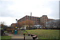
37 Bowater Road
The long brick range of the former cable factory, the most significant of the few surviving elements of the large Siemens works which once dominated the area. It closed in 1968. Among other things, this site was responsible for pioneering work on trans-continental telegraph cables, and was involved in constructing oil pipelines to assist the D-Day landings (the PLUTO project). This building was erected c1911 using the Kahn Concrete system. Grade II listed.
Despite that, the present owner wanted to demolish it as part of a regeneration scheme. A Certificate of Immunity from Listing was sought, but instead Historic England decided to list it, for which reason plans appear to be in abeyance.
Image: © Stephen Richards
Taken: 21 Nov 2020
0.04 miles