IMAGES TAKEN NEAR TO
Ruston Road, LONDON, SE18 5QZ
Introduction
This page details the photographs taken nearby to Ruston Road, SE18 5QZ by members of the Geograph project.
The Geograph project started in 2005 with the aim of publishing, organising and preserving representative images for every square kilometre of Great Britain, Ireland and the Isle of Man.

There are currently over 7.5m images from over14,400 individuals and you can help contribute to the project by visiting https://www.geograph.org.uk
Image Map
Images are licensed for reuse under creativecommons.org/licenses/by-sa/2.0
Notes
- Clicking on the map will re-center to the selected point.
- The higher the marker number, the further away the image location is from the centre of the postcode.
Image Listing (115 Images Found)
Images are licensed for reuse under creativecommons.org/licenses/by-sa/2.0
Image
Details
Distance
1
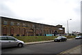
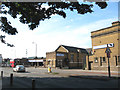
Former Smithery and Brass Foundry, Royal Dockyard
Grade II listed. http://www.britishlistedbuildings.co.uk/en-398684-former-smithery-erecting-shop-and-brass-
Image: © N Chadwick
Taken: 17 Feb 2012
0.05 miles
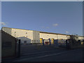
4
Police patrol base, Warspite Road
This anonymous warehouse unit, accessed off Ruston Road (foreground) but with an address on Warspite Road, gives no obvious clue to its occupants' business. But it is well known in the locality to be a police facility ("Greenwich patrol base"). This is public knowledge and planning permission was obtained for the change of use.
Image: © Stephen Craven
Taken: 19 Feb 2012
0.06 miles
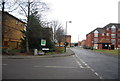
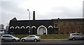
5
Co-Operative Funerals
An extensive range of buildings housing the Woolwich branch of Co-Operative Funeralcare. Woolwich was one of the places where the Co-Operative movement started in the 1840's.
Image: © Stephen Craven
Taken: 26 Aug 2007
0.07 miles
6
Former Smithery and Brass Foundry, Royal Dockyard
Grade II listed. http://www.britishlistedbuildings.co.uk/en-398684-former-smithery-erecting-shop-and-brass-
Image: © N Chadwick
Taken: 17 Feb 2012
0.08 miles
7
Police patrol base, Warspite Road
For another view of this building see Image
Image: © Stephen Craven
Taken: 16 Feb 2014
0.08 miles
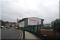
8
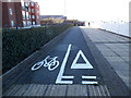
Misleading cycle lane
For anyone walking or cycling the Thames Path westwards from Woolwich this is a misleading marking: they should have turned left at this point onto a permanent diversion, though it is not signed as such. The path comes to an abrupt end 60 metres further on: Image The two cyclists visible in this picture had just made that mistake.
Image: © Stephen Craven
Taken: 16 Feb 2014
0.09 miles
9

Co-operative Funeral Care Offices
This building was built to match Image
When the company took over the site.
Image: © David Anstiss
Taken: 11 Sep 2011
0.09 miles
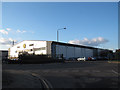
10
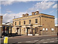
Former Woolwich Dockyard Police Station
This Grade II listed building was built in 1843 to serve the nearby Woolwich Dockyard. Since the closure of the Dockyard, it is now offices and used by the Co-operative Funeralcare company.
See http://www.britishlistedbuildings.co.uk/en-398683-former-police-station-to-royal-dockyard- for more details about the building.
Image: © David Anstiss
Taken: 11 Sep 2011
0.09 miles