IMAGES TAKEN NEAR TO
Maud Cashmore Way, LONDON, SE18 5QS
Introduction
This page details the photographs taken nearby to Maud Cashmore Way, SE18 5QS by members of the Geograph project.
The Geograph project started in 2005 with the aim of publishing, organising and preserving representative images for every square kilometre of Great Britain, Ireland and the Isle of Man.

There are currently over 7.5m images from over14,400 individuals and you can help contribute to the project by visiting https://www.geograph.org.uk
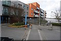
Image Map
Images are licensed for reuse under creativecommons.org/licenses/by-sa/2.0
Notes
- Clicking on the map will re-center to the selected point.
- The higher the marker number, the further away the image location is from the centre of the postcode.
Image Listing (188 Images Found)
Images are licensed for reuse under creativecommons.org/licenses/by-sa/2.0
Image
Details
Distance
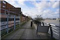
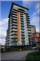
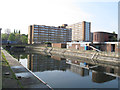
2
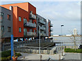
Lower Mast House, Woolwich
Riverside flats.
Image: © Robin Webster
Taken: 5 Mar 2011
0.02 miles
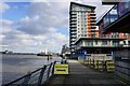
3
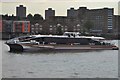
Thames Clipper
Seen near Woolwich ferry http://en.wikipedia.org/wiki/Thames_Clippers
Image: © Ashley Dace
Taken: 30 Sep 2010
0.03 miles
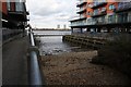
8
Woolwich graving docks: eastern dock
The two graving docks by the Thames west of Woolwich town centre are part of the early 19th century redevelopment of the Royal Dockyard. They are listed grade 2 (list entry number 1212422). Their historical significance is that they are probably on the site of the earliest English Royal Docks from the 1530s.
Image: © Stephen Craven
Taken: 21 Apr 2014
0.04 miles
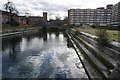
9
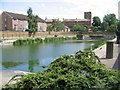
Eastern dock, former Woolwich dockyard
One of the two surviving docks of the former Royal Dockyard at Woolwich. The earliest dock on this site was built in 1512, but it has been rebuilt at least thrice in 1635, 1720 and in the early 19th century. Now listed grade 2 (list entry number 1212422). NB I had originally and incorrectly described this as the former mast pond, which in fact lay further east.
Image: © Stephen Craven
Taken: 8 Jul 2006
0.04 miles