IMAGES TAKEN NEAR TO
Mast Quay, LONDON, SE18 5NP
Introduction
This page details the photographs taken nearby to Mast Quay, SE18 5NP by members of the Geograph project.
The Geograph project started in 2005 with the aim of publishing, organising and preserving representative images for every square kilometre of Great Britain, Ireland and the Isle of Man.

There are currently over 7.5m images from over14,400 individuals and you can help contribute to the project by visiting https://www.geograph.org.uk
Image Map (218 Images)


Getting Data...Please wait
Leaflet Map data © OpenStreetMap
Images are licensed for reuse under creativecommons.org/licenses/by-sa/2.0
Notes
- Clicking on the map will re-center to the selected point.
- The higher the marker number, the further away the image location is from the centre of the postcode.
Image Listing (218 Images Found)
Images are licensed for reuse under creativecommons.org/licenses/by-sa/2.0
Image
Details
Distance
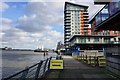
1
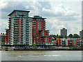
Waterfront flats, Woolwich
Mizzen Mast House on the left, Jigger Mast House on the right.
Image: © Robin Webster
Taken: 30 Jun 2011
0.01 miles
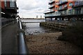
6

The Thames at Woolwich
Focal point is the Woolwich ferry vessel John Burns. Canary wharf is beyond it and the flood barrier is catching the sun.
Image: © Chris Allen
Taken: 19 Oct 2008
0.05 miles
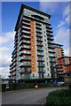
7
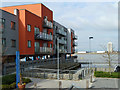
Lower Mast House, Woolwich
Riverside flats.
Image: © Robin Webster
Taken: 5 Mar 2011
0.05 miles
9
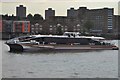
Thames Clipper
Seen near Woolwich ferry http://en.wikipedia.org/wiki/Thames_Clippers
Image: © Ashley Dace
Taken: 30 Sep 2010
0.06 miles
