IMAGES TAKEN NEAR TO
Woolwich Church Street, LONDON, SE18 5ND
Introduction
This page details the photographs taken nearby to Woolwich Church Street, SE18 5ND by members of the Geograph project.
The Geograph project started in 2005 with the aim of publishing, organising and preserving representative images for every square kilometre of Great Britain, Ireland and the Isle of Man.

There are currently over 7.5m images from over14,400 individuals and you can help contribute to the project by visiting https://www.geograph.org.uk
Image Map
Images are licensed for reuse under creativecommons.org/licenses/by-sa/2.0
Notes
- Clicking on the map will re-center to the selected point.
- The higher the marker number, the further away the image location is from the centre of the postcode.
Image Listing (176 Images Found)
Images are licensed for reuse under creativecommons.org/licenses/by-sa/2.0
Image
Details
Distance
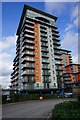
1
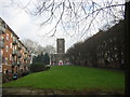
Woolwich: flats west of St Mary Magdalen church
Image: © Christopher Hilton
Taken: 20 Jan 2016
0.01 miles
6
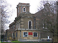
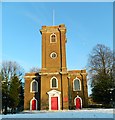
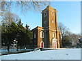
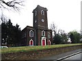
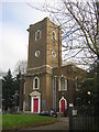
St Mary Magdalene church, Woolwich
An Anglican parish church on the western edge of the town centre, but in a historically prominent position overlooking the river Thames. This is a view of the East end and South side of the church.
The building is listed grade 2* (listed building no. 200362 or Heritage asset number 1358969 from 2011). It was built in 1727-39 "by a Deptford bricklayer, Matthew Spray" but the architect's name is unknown. The east end was rebuilt and extended with transepts in 1893-94 by J.O. Scott, and there were further modifications in the 20th century. These including the screening-off of the upper part of the galleries in 1961 - the North gallery was turned into a Coffee House open Monday to Friday for local workers and the South gallery turned into a Parish Lounge for use for church social events, committee meetings and the like; the glass screens were removed in 2009. The aisles below the galleries were partitioned off to form offices in 1967 to house the local Council of Social Services. At the same time the crypt under the 1890s extension was dug out to form an unusual Youth Club area with a separate entrance, just visible at the right-hand side of the photograph.
Image: © Stephen Craven
Taken: 13 Mar 2005
0.07 miles
7
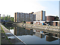
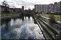
Woolwich graving docks: eastern dock
The two graving docks by the Thames west of Woolwich town centre are part of the early 19th century redevelopment of the Royal Dockyard. They are listed grade 2 (list entry number 1212422). Their historical significance is that they are probably on the site of the earliest English Royal Docks from the 1530s.
Image: © Stephen Craven
Taken: 21 Apr 2014
0.07 miles