IMAGES TAKEN NEAR TO
Samuel Close, LONDON, SE18 5LR
Introduction
This page details the photographs taken nearby to Samuel Close, SE18 5LR by members of the Geograph project.
The Geograph project started in 2005 with the aim of publishing, organising and preserving representative images for every square kilometre of Great Britain, Ireland and the Isle of Man.

There are currently over 7.5m images from over14,400 individuals and you can help contribute to the project by visiting https://www.geograph.org.uk
Image Map (Loading...)


Getting Data...Please wait
Leaflet Map data © OpenStreetMap
Images are licensed for reuse under creativecommons.org/licenses/by-sa/2.0
Notes
- Clicking on the map will re-center to the selected point.
- The higher the marker number, the further away the image location is from the centre of the postcode.
Image Listing (133 Images Found)
Images are licensed for reuse under creativecommons.org/licenses/by-sa/2.0
Image
Details
Distance
1
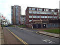
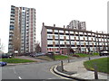
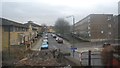
Marshalls Grove, Woolwich
Housing on Marshalls Grove, close to Woolwich in south east London.
Image: © Malc McDonald
Taken: 30 Dec 2017
0.06 miles
2
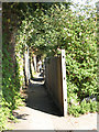
Urban footpath
An urban footpath or snicket running parallel to the railway line, between the junction of Maryon Road and Woodhill (the end shown here) and Prospect Vale.
Image: © Stephen Craven
Taken: 26 Aug 2007
0.07 miles
3
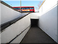
Slope down to the subway
A modern access ramp leading from Woolwich Church Street down to the 19th century subway shown in Image, which is in the next grid square (the line being crossed roughly at the subway entrance).
Image: © Stephen Craven
Taken: 19 Feb 2012
0.07 miles
4
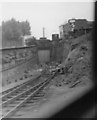
Former rail link to Woolwich Dockyard
A photograph from a train on the down line looking at the former railway link via a tunnel under Woolwich Church Street into the Royal Dockyard, taken in 1962 after the line had become disused. The tunnel was eventually converted into a pedestrian underpass when the dockyard redevelopment was started. See Image in the adjacent northern square.
The thin object on the skyline over the tunnel entrance is a large brick chimney at the far end of the dockyard.
Scanned from a 2.25 inch square black and white negative. Slight blurring due to the train movement. Picture cropped to remove large sky area.
Image: © John Webb
Taken: Unknown
0.07 miles
5
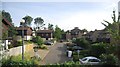
Housing near Woolwich
Low-rise and high-rise flats on Samuel Street, near Woolwich in south east London.
Image: © Malc McDonald
Taken: 30 Dec 2017
0.07 miles
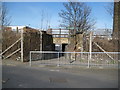
7
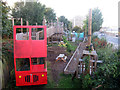
Games Court Adventure Playground
Image: © Oast House Archive
Taken: 14 Oct 2012
0.08 miles
9
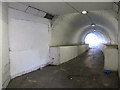
Subway under Woolwich Church Street
A short brick-lined pedestrian tunnel connecting Prospect Vale to what is now Boneta Road on the north side, but was originally part of the Woolwich Royal Dockyard. It is still a useful way to get down to the river without crossing the main road. But it was originally built for a railway line into the former dockyard - see Image taken from the square to the south - and has had the floor raised considerably to minimise the access ramp and steps. Construction of the dock railway, including this tunnel, required the demolition of fourteen houses, and took from 1873 to 1880.
Image: © Stephen Craven
Taken: 19 Feb 2012
0.09 miles
10
Woolwich: Pett Street / Woodhill subway
Taken from a little further away than Stephen's Image with Image on the right and the roof of Image just visible on the left, the pedestrian subway goes under the railway line about 500 metres west of Woolwich Dockyard railway station. The silver car visible through the subway is on Woolwich Church Street.
Image: © Nigel Cox
Taken: 5 Mar 2008
0.10 miles