IMAGES TAKEN NEAR TO
Bowling Green Row, LONDON, SE18 5LH
Introduction
This page details the photographs taken nearby to Bowling Green Row, SE18 5LH by members of the Geograph project.
The Geograph project started in 2005 with the aim of publishing, organising and preserving representative images for every square kilometre of Great Britain, Ireland and the Isle of Man.

There are currently over 7.5m images from over14,400 individuals and you can help contribute to the project by visiting https://www.geograph.org.uk
Image Map
Images are licensed for reuse under creativecommons.org/licenses/by-sa/2.0
Notes
- Clicking on the map will re-center to the selected point.
- The higher the marker number, the further away the image location is from the centre of the postcode.
Image Listing (127 Images Found)
Images are licensed for reuse under creativecommons.org/licenses/by-sa/2.0
Image
Details
Distance
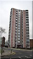
3
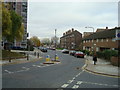
Housing near Woolwich
Low-rise and high-rise flats on Samuel Street, near Woolwich in south east London.
Image: © Malc McDonald
Taken: 30 Dec 2017
0.03 miles
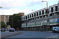
4
Marshalls Grove, Woolwich
Housing on Marshalls Grove, close to Woolwich in south east London.
Image: © Malc McDonald
Taken: 30 Dec 2017
0.04 miles
6
Woolwich Dockyard Railway Station
The sweeping 'S' of the railway seen looking West as it curves through Woolwich Dockyard station.
Image: © David Robinson
Taken: 6 Jun 2018
0.05 miles
8
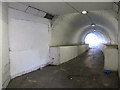
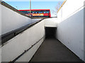
Subway under Woolwich Church Street
A short brick-lined pedestrian tunnel connecting Prospect Vale to what is now Boneta Road on the north side, but was originally part of the Woolwich Royal Dockyard. It is still a useful way to get down to the river without crossing the main road. But it was originally built for a railway line into the former dockyard - see Image taken from the square to the south - and has had the floor raised considerably to minimise the access ramp and steps. Construction of the dock railway, including this tunnel, required the demolition of fourteen houses, and took from 1873 to 1880.
Image: © Stephen Craven
Taken: 19 Feb 2012
0.06 miles
9
Slope down to the subway
A modern access ramp leading from Woolwich Church Street down to the 19th century subway shown in Image, which is in the next grid square (the line being crossed roughly at the subway entrance).
Image: © Stephen Craven
Taken: 19 Feb 2012
0.07 miles
10
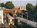
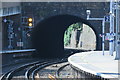
West end of Woolwich Dockyard station
The station opened in 1849, to serve the nearby Royal Dockyard. The area was fast expanding at the time: for example the nearby church of St Thomas Image was opened the same year. The line between Greenwich and Woolwich is largely in cutting or tunnel, and the Dockyard station itself is wedged between short tunnels at each end, meaning that this line can never be extended to take 12-coach trains as other suburban lines in London do.
Not all trains stop here. In this view taken at 08.10 in the morning rush-hour, the left-hand train is a through service (07.41 Gravesend to Cannon Street via Lewisham), and the green light indicates that the Charlton Lane level crossing Image has already been opened ready for it. The train at right is empty stock returning to Slade Green depot.
Image: © Stephen Craven
Taken: 22 Sep 2003
0.07 miles