IMAGES TAKEN NEAR TO
Eleanor Walk, LONDON, SE18 5EA
Introduction
This page details the photographs taken nearby to Eleanor Walk, SE18 5EA by members of the Geograph project.
The Geograph project started in 2005 with the aim of publishing, organising and preserving representative images for every square kilometre of Great Britain, Ireland and the Isle of Man.

There are currently over 7.5m images from over14,400 individuals and you can help contribute to the project by visiting https://www.geograph.org.uk
Image Map
Images are licensed for reuse under creativecommons.org/licenses/by-sa/2.0
Notes
- Clicking on the map will re-center to the selected point.
- The higher the marker number, the further away the image location is from the centre of the postcode.
Image Listing (113 Images Found)
Images are licensed for reuse under creativecommons.org/licenses/by-sa/2.0
Image
Details
Distance
1
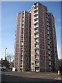
Woolwich: 71 - 177 Frances Street, SE18
One of five towerblocks built between Frances Street and Samuel Street, this one has 14 storeys and was completed in 1963. It is about 138 feet or about 42 metres high from ground level to the top.
Image: © Nigel Cox
Taken: 5 Mar 2008
0.05 miles
2
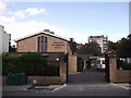
Woolwich Evangelical Church
On Woodhill (road).
Image: © David Anstiss
Taken: 11 Sep 2011
0.07 miles
3
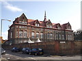
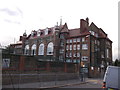
Woodhill School, Woolwich
This large Grade II listed school is on Woodhill (road).
See http://www.britishlistedbuildings.co.uk/en-396776-woodhill-school-woolwich for more details about the building.
Image: © David Anstiss
Taken: 11 Sep 2011
0.09 miles
4
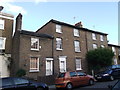
153-159 Woodhill
Row of four grade II listed houses. 2 two storey houses and 2 3 storey houses.
See http://www.britishlistedbuildings.co.uk/en-396774-153-159-woolwich for more details about the buildings.
Image: © David Anstiss
Taken: 11 Sep 2011
0.09 miles
5
Woodhill School, Woolwich (2)
This large Grade II listed school is on Woodhill (road).
See Link for more details about the building
Image: © David Anstiss
Taken: 11 Sep 2011
0.09 miles
6
Former St Michael & All Angels, Borgard Road, Woolwich
Now the Church of Pentecost UK Jubilee Temple.
Image: © Christopher Hilton
Taken: 20 Jan 2016
0.11 miles
7
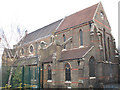
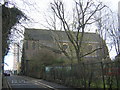
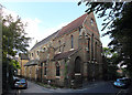
St Michael & All Angels church, Woolwich
The church is on Borgard Road. This is the liturgical east end (but actually facing south-east). It was built c. 1878-1889 but there was never sufficient money to complete the original designs of the architect (William Butterfield, who was also responsible for Melbourne Cathedral, Australia with which it shares several architectural details). The south aisle and tower were constructed in 1954 to the designs of Thomas Ford. The church is listed grade C.
For a view of the west end see Image
Image: © Stephen Craven
Taken: 4 Mar 2010
0.12 miles
8
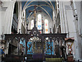
Rood screen of St Michael's church
The most notable feature of the interior of the church of St Michael & All Angels Image is this rood screen.
Image: © Stephen Craven
Taken: 4 Mar 2010
0.12 miles
9
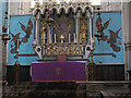
High Altar of St Michael's church
The altar of Image
Image: © Stephen Craven
Taken: 4 Mar 2010
0.12 miles
10
St Michael & All Angels, Borgard Road, Woolwich, London SE18
Image: © John Salmon
Taken: 9 Sep 2014
0.12 miles