IMAGES TAKEN NEAR TO
Stane Way, LONDON, SE18 4PA
Introduction
This page details the photographs taken nearby to Stane Way, SE18 4PA by members of the Geograph project.
The Geograph project started in 2005 with the aim of publishing, organising and preserving representative images for every square kilometre of Great Britain, Ireland and the Isle of Man.

There are currently over 7.5m images from over14,400 individuals and you can help contribute to the project by visiting https://www.geograph.org.uk
Image Map
Images are licensed for reuse under creativecommons.org/licenses/by-sa/2.0
Notes
- Clicking on the map will re-center to the selected point.
- The higher the marker number, the further away the image location is from the centre of the postcode.
Image Listing (96 Images Found)
Images are licensed for reuse under creativecommons.org/licenses/by-sa/2.0
Image
Details
Distance
1
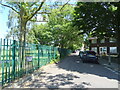
Stane Way
Looking north east beside Hornfair Park.
Image: © JThomas
Taken: 20 Jun 2022
0.01 miles
3
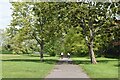
Avenue of trees on edge of Hornfair Park
Image: © David Martin
Taken: 9 May 2021
0.04 miles
5
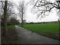
Hornfair Park: perimeter path
A macadam surfaced path running around the playing fields at the eastern end of the park.
Image: © Stephen Craven
Taken: 27 Feb 2011
0.06 miles
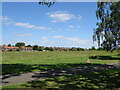
9
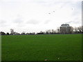
Hornfair Park: football pitches
There are several football pitches laid out on the main open space of the park. The tall building in the distance is the Queen Elizabeth Hospital.
Image: © Stephen Craven
Taken: 27 Feb 2011
0.07 miles
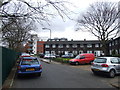
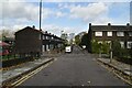
10
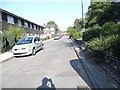
Tellson Avenue, Shooters Hill
The red fence at the end is the demolition site of the remainder of the road.
Image: © David Howard
Taken: 18 May 2014
0.07 miles