IMAGES TAKEN NEAR TO
Shooters Hill Road, LONDON, SE18 4LH
Introduction
This page details the photographs taken nearby to Shooters Hill Road, SE18 4LH by members of the Geograph project.
The Geograph project started in 2005 with the aim of publishing, organising and preserving representative images for every square kilometre of Great Britain, Ireland and the Isle of Man.

There are currently over 7.5m images from over14,400 individuals and you can help contribute to the project by visiting https://www.geograph.org.uk
Image Map
Images are licensed for reuse under creativecommons.org/licenses/by-sa/2.0
Notes
- Clicking on the map will re-center to the selected point.
- The higher the marker number, the further away the image location is from the centre of the postcode.
Image Listing (102 Images Found)
Images are licensed for reuse under creativecommons.org/licenses/by-sa/2.0
Image
Details
Distance
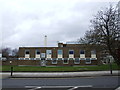
1
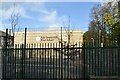
Kidbrooke Telephone Exchange
Off Shooters Hill Road.
Image: © JThomas
Taken: 20 Jun 2022
0.01 miles
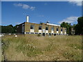
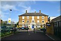
3
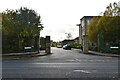
Shooters Hill Road, A207
By the former Royal Herbert Military Hospital, on the left, now flats.
Image: © Robin Webster
Taken: 14 Mar 2012
0.03 miles
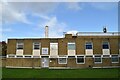
6
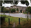
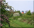
London, SE18 - Shooters Hill Area
A view of the new (c.1995) entrance into the former Royal Herbert (Military) Hospital site from a public footpath on the opposite side of Shooters Hill Road (the A207), near to its junction with Well Hall Road (the A205). The hospital - in its entirety - was commissioned by Sir Sidney Herbert, Minister of War, who commissioned Florence Nightingale and her nurses to go to the Crimean War and who supported her health-related and care-related reforms for British military personnel at home and abroad. This establishment was created as a restorative facility for veterans of the Crimean War and opened in 1865. It eventually became the British Army's principal orthopaedic centre but finally closed in 1977 having became superfluous to military requirements. By 1995, it had been saved from demolition and had been converted into 228 private apartments known collectively as The Royal Herbert Pavilions.
Image: © David Hallam-Jones
Taken: 30 Sep 2012
0.04 miles
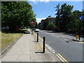
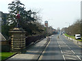
9
Woolwich Common, London SE18
This footpath running parallel with Academy Road appears to follow a c-shaped curve here towards the former 130ft high former water tower on the site of the former Brook Hospital, Shooters Hill. In fact the path exits in front of the former Royal Herbert (Military) Hospital site - now private apartments - situated Shooters Hill. On the south-east side of the common (i.e. behind the photographers left shoulder) is the former Royal Military Academy that was built in 1805 to train officer cadets studying for the Royal Artillery and Royal Engineers. The former Royal Military Academy site is now home to several hundred private apartments, many within the original military buildings.
Image: © David Hallam-Jones
Taken: 4 May 2014
0.05 miles