IMAGES TAKEN NEAR TO
Bagshot Court, Prince Imperial Road, LONDON, SE18 4JS
Introduction
This page details the photographs taken nearby to Bagshot Court, Prince Imperial Road, SE18 4JS by members of the Geograph project.
The Geograph project started in 2005 with the aim of publishing, organising and preserving representative images for every square kilometre of Great Britain, Ireland and the Isle of Man.

There are currently over 7.5m images from over14,400 individuals and you can help contribute to the project by visiting https://www.geograph.org.uk
Image Map
Images are licensed for reuse under creativecommons.org/licenses/by-sa/2.0
Notes
- Clicking on the map will re-center to the selected point.
- The higher the marker number, the further away the image location is from the centre of the postcode.
Image Listing (105 Images Found)
Images are licensed for reuse under creativecommons.org/licenses/by-sa/2.0
Image
Details
Distance
1
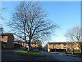
Prince Imperial Road, Woolwich
Most of the roads in this area around the former Woolwich Military Academy have military or royal names. I am unsure whether the housing did or still does belong to the Army.
Image: © Stephen Craven
Taken: 11 Jan 2014
0.04 miles
2
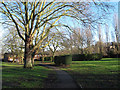
Path towards Red Lion Lane
The path leads from the dead end of Academy Place Image towards Prince Imperial Road and thence to Red Lion Lane.
Image: © Stephen Craven
Taken: 11 Jan 2014
0.04 miles
3
Path towards Academy Place
Looking southwards from the northern end of the path: see also Image
Image: © Stephen Craven
Taken: 11 Jan 2014
0.04 miles
4
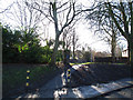
Two-way traffic starts here
Red Lion Lane is one-way downhill as far as this point. TO the right just beyond the width restriction is the entrance to "Shooters Hill Post 16 campus" Image
Image: © Stephen Craven
Taken: 11 Jan 2014
0.08 miles
5

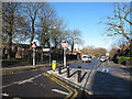
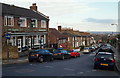
Red Lion Lane, London SE18
With the Eagle pub at a top of a slight hill behind the photographer, this is a continuation of the gentle downward slope towards Woolwich Common. The traffic-calming devices are an attempt to slow vehicles down outside the entrance to Shooter's Hill Post-16 College (on the right, behind the waste bin). In a former life it was Shooter's Hill Grammar School. It amalgamated with Bloomfield Secondary Modern School in 1973 and became Eaglesfield Comprehensive School, closing in 2005. The comedian "Frankie" Howerd (1917-92), who lived in nearby Eltham, described himself as having been "lightly educated" here when it was a grammar school.
Image: © David Hallam-Jones
Taken: 2 Jan 2013
0.09 miles
6
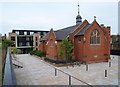
Former Royal Military Academy - SE18
A view of the Church of St Michael and All Angels (1902-04) situated in an area that is now referred to as Village Square by the site developers, together with a block of new houses in the distance. According to their promotional material the developers have already committed themselves to converting the church into an arts and culture centre providing studio space for local artists and an open space for the use of residents for exercise classes, art lessons and cultural events.
Image: © David Hallam-Jones
Taken: 6 Aug 2012
0.09 miles
7
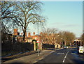
Red Lion Lane, London SE18
As Red Lion Lane descends towards where Woolwich Common (i.e. the road ahead) joins Herbert Road (that branches off to the right), the castellated buildings of former Royal Military Academy site are visible on the left. The gateposts on the left - immediately behind the "Two Way Traffic" road sign - however, is a private cul-de-sac called Prince Imperial Road that services a small estate of "Ministry of Defence" residential accommodation.
Image: © David Hallam-Jones
Taken: 2 Jan 2013
0.09 miles
8
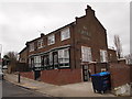
Red Lion Lane, Woolwich, London SE18
The former Eagle Tavern sitting halfway along Red Lion Lane, a road linking Shooter's Hill (ahead) with Woolwich Common. It was converted into a small number of flats in 2015.
Image: © David Hallam-Jones
Taken: 20 Mar 2016
0.09 miles
9
Red Lion Lane, London SE18
The Eagle Tavern is situated approximately halfway along Red Lion Lane, a road that connects Shooter's Hill with Woolwich Common. The road joining Red Lion Lane on the right of the picture is Constitution Rise.
Image: © David Hallam-Jones
Taken: 2 Jan 2013
0.09 miles
10
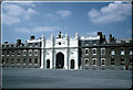
Grand Depot
Royal Artillery Grand Depot block, Woolwich, photographed in 1959. The Royal Artillery, long associated with Woolwich, are now moving to Larkhill in Wiltshire.
Image: © David Wright
Taken: Unknown
0.10 miles