IMAGES TAKEN NEAR TO
Nightingale Place, LONDON, SE18 4HU
Introduction
This page details the photographs taken nearby to Nightingale Place, SE18 4HU by members of the Geograph project.
The Geograph project started in 2005 with the aim of publishing, organising and preserving representative images for every square kilometre of Great Britain, Ireland and the Isle of Man.

There are currently over 7.5m images from over14,400 individuals and you can help contribute to the project by visiting https://www.geograph.org.uk
Image Map (Loading...)


Getting Data...Please wait
Leaflet Map data © OpenStreetMap
Images are licensed for reuse under creativecommons.org/licenses/by-sa/2.0
Notes
- Clicking on the map will re-center to the selected point.
- The higher the marker number, the further away the image location is from the centre of the postcode.
Image Listing (60 Images Found)
Images are licensed for reuse under creativecommons.org/licenses/by-sa/2.0
Image
Details
Distance
2
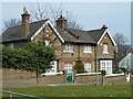
Houses on Nightingale Place, Woolwich
These seem to have once been part of the War Department property here.
Image: © Robin Webster
Taken: 14 Mar 2012
0.03 miles
4
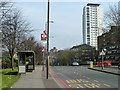
Bus stop S, Nightingale Place, Woolwich
Named Woolwich Common, and served by route 244 towards Shooters Hill.
Image: © Robin Webster
Taken: 14 Mar 2012
0.05 miles
6
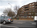
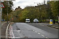
Flats on the corner of Woolwich Common and Nightingale Place
Image: © David Howard
Taken: 23 Feb 2014
0.08 miles
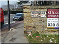
7
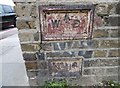
Old Boundary Marker by Nightingale Place, Woolwich
Estate Boundary Marker - War Department by the UC road, in parish of Woolwich (Greenwich District), Nightingale Place SE18, at junction Grand Depot Road, set in wall.
Surveyed
Milestone Society National ID: KE_WDWOO01em.
Image: © Milestone Society
Taken: Unknown
0.08 miles
9
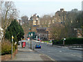
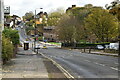
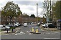
Nightingale Place, Woolwich
Looking down into the valley of a brook which now seems to be entirely covered over, but there are several street names betraying its existence. The specific name of the brook, if it had one, has so far eluded me.
Image: © Robin Webster
Taken: 14 Mar 2012
0.09 miles
10
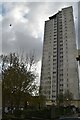
War Department boundary marker no. 1, Woolwich
There was a lot of military property in Woolwich, this was a military hospital, the site now sold off for housing. Nightingale Place probably takes its name from Florence Nightingale.
Image: © Robin Webster
Taken: 14 Mar 2012
0.09 miles