IMAGES TAKEN NEAR TO
Tellson Avenue, LONDON, SE18 4EE
Introduction
This page details the photographs taken nearby to Tellson Avenue, SE18 4EE by members of the Geograph project.
The Geograph project started in 2005 with the aim of publishing, organising and preserving representative images for every square kilometre of Great Britain, Ireland and the Isle of Man.

There are currently over 7.5m images from over14,400 individuals and you can help contribute to the project by visiting https://www.geograph.org.uk
Image Map
Images are licensed for reuse under creativecommons.org/licenses/by-sa/2.0
Notes
- Clicking on the map will re-center to the selected point.
- The higher the marker number, the further away the image location is from the centre of the postcode.
Image Listing (82 Images Found)
Images are licensed for reuse under creativecommons.org/licenses/by-sa/2.0
Image
Details
Distance
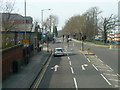
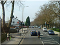
1
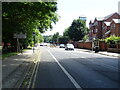
Shooters Hill Road (A207)
Looking south east on an old Roman Road.
Image: © JThomas
Taken: 20 Jun 2022
0.03 miles
5
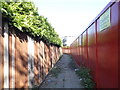
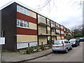
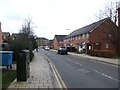
Path behind Tellson Avenue, Shooters Hill
The flats on the right are being demolished and the whole site is blocked by the fence.
Image: © David Howard
Taken: 18 May 2014
0.03 miles
7
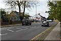
Junction on A207
The road right goes to the Queen Elizabeth Hospital and beyond.
Image: © Robin Webster
Taken: 14 Mar 2012
0.05 miles
8
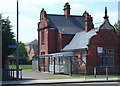
Shooters Hill, London SE18
The former main gate lodge of the former Brook Hospital is seen here from Shooters Hill (the A207) at its junction with Baker Road. "The Brook" was closed in 1995 when the Queen Elizabeth (District General) Hospital opened and most of the site was redeveloped into a housing complex, now known as Brook Village. The only remaining former hospital buildings are the water tower, the administration block, the steward's house and this lodge, that now houses a Children's Centre.
Image: © David Hallam-Jones
Taken: 3 May 2014
0.05 miles
10
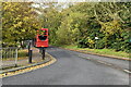
Shooters Hill Road, A207
Along the route of the Roman Watling Street, not quite as straight here now as further back.
Image: © Robin Webster
Taken: 14 Mar 2012
0.06 miles