IMAGES TAKEN NEAR TO
Greenhill, LONDON, SE18 4BN
Introduction
This page details the photographs taken nearby to Greenhill, SE18 4BN by members of the Geograph project.
The Geograph project started in 2005 with the aim of publishing, organising and preserving representative images for every square kilometre of Great Britain, Ireland and the Isle of Man.

There are currently over 7.5m images from over14,400 individuals and you can help contribute to the project by visiting https://www.geograph.org.uk
Image Map
Images are licensed for reuse under creativecommons.org/licenses/by-sa/2.0
Notes
- Clicking on the map will re-center to the selected point.
- The higher the marker number, the further away the image location is from the centre of the postcode.
Image Listing (50 Images Found)
Images are licensed for reuse under creativecommons.org/licenses/by-sa/2.0
Image
Details
Distance
1
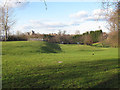
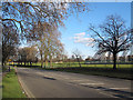
Military grassland
Open land outside the barracks on Repository Road Image Although not fenced off I'm pretty sure it's military land.
Image: © Stephen Craven
Taken: 19 Feb 2012
0.04 miles
2
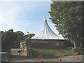
The Rotunda, Woolwich
The Rotunda is an unusual 24-sided building with a tent-like roof, designed by John Nash and built in 1814 (moved from its original location to the Royal Artillery site at Woolwich in 1820). It was used for military training purposes and later as the regimental museum 'Firepower', which moved to the Royal Arsenal site circa 2003. This building is not presently open to the public, but is listed grade II* and on the English Heritage 'buildings at risk register' as its future seems uncertain.
Image: © Stephen Craven
Taken: 20 Sep 2008
0.08 miles
3
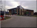
New home for the Kings Troop (1)
Part of the new barracks for the King's Troop [Royal Horse Artillery] in Woolwich. They moved from their previous barracks in St John's Wood Image on 7 February 2012. Facilities here include an equestrian training facility and accommodation.
Image: © Stephen Craven
Taken: 19 Feb 2012
0.09 miles
4
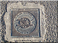
Woolwich Millennium Heritage Trail
One of a series of ground plaques, this one outside the barracks on Repository Road Image
Image: © Stephen Craven
Taken: 19 Feb 2012
0.09 miles
5
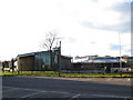
New home for the Kings Troop (2)
Part of the new barracks for the King's Troop [Royal Horse Artillery] in Woolwich. They moved from their previous barracks in St John's Wood Image on 7 February 2012. Facilities here include an equestrian training facility and accommodation.
Image: © Stephen Craven
Taken: 19 Feb 2012
0.09 miles
6
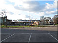
Repository Road, Woolwich
This short road connects Ha-Ha Road with Littleheath, and runs through between military establishments. It gets its name from the forerunner of the present Firepower army museum.
Image: © Stephen Craven
Taken: 19 Feb 2012
0.10 miles
7
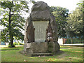
Afghan & South African war memorial, Woolwich
The memorial, on the edge of Repository Road (a public road running through the Royal Artillery site), commemorates the British dead of the Afghan and South African wars 1877-1881.
Image: © Stephen Craven
Taken: 20 Sep 2008
0.13 miles
8
View from Repository Road
In the distance can be seen the Royal Artillery Barracks. For a close up of the barracks see https://www.geograph.org.uk/photo/6732016
Image: © Marathon
Taken: 25 Jan 2021
0.14 miles
9
Olympic preparations in Woolwich
This steel frame has been erected prior to the 2012 Olympic shooting events being held here at the former Royal Artillery site in Woolwich. It was not clear whether this is the finished structure and what it is for, or whether it's only the framework for seating or some other structure.
Image: © Stephen Craven
Taken: 19 Feb 2012
0.14 miles